Supplement to:
DISTRIBUTION AND SOURCES OF SECONDARY DEPOSIT ARCHAEOLOGICAL OBSIDIAN IN RIO GRANDE ALLUVIUM NEW MEXICO, USA
Geoarcheology 2021, 36:808-825
M. Steven Shackley
Jemez Lineament Obsidian Sources for the Rio Grande Secondary Obsidian Deposit Study (see also http://swxrflab.net/jemez.htm, and http://swxrflab.net/grants.htm)
JEMEZ LINEAMENT SOURCES
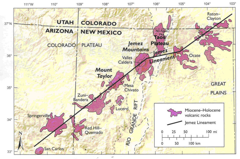
All of the artifact quality sources recovered in Rio Grande Quaternary alluvium are derived from Jemez Lineament volcanism (Aldrich, 1986; Gardner et al., 1986). According to Aldrich the Jemez lineament describes a NE trending crustal flaw that controlled volcanism and tectonism in the Jemez Mountains and the Rio Grande rift zone including the Mount Taylor volcanic field at the interface between the rift and the Colorado Plateau (Aldrich, 1986; Goff and Gardner, 2004; Goff et al., 2019). Along the lineament is a string of Miocene to Holocene volcanic fields and volcanoes including the Mount Taylor and the Jemez Mountains fields, all of which have eroded in variable quantities into the ancestral Rio Puerco and Rio Grande respectively (Baker and Ridley, 1970; Shackley, 1998, 2005). This volcanism has occurred in a transition zone between the Colorado Plateau, and the Rio Grande Rift, and in part this origin is reflected in the elemental composition of the obsidian (Baker and Ridley, 1970; Shackley, 1998, 2005; Supplemental Figure 1 here).
Supplemental Figure 1. Location of the Jemez Lineament with relevant obsidian sources at Mount Taylor, the Jemez Mountains, and No Agua Peaks (adapted from Aldrich 1986; Goff and Gardner 2004; Goff et al. 2019).
TAOS PLATEAU VOLCANIC FIELD AND NO AGUA PEAKS
The No Agua perlite/obsidian source has been reported various times in the geological and archaeological literature (Appelt 1998; Baugh and Nelson 1987; Ennis 2011; Glascock et al. 1999; Lipman and Mehnert 1979; Naert et al. 1980; Stevenson and McCurry, 1990; Whitson, 1982; Figure 1 in text, Supplemental Figure 1). Lipman and Mehnert (1979) describe the No Agua Peak source as part of the multi-modal Taos Plateau volcanic field providing field descriptions, major and elemental chemistry and K-Ar dates for the obsidian proper (see also Appelt, 2011). The No Agua source has been extensively disturbed by recent and past perlite mining; currently the El Grande Perlite Mine. This is Lipman and Mehnert's description from the 1970s:
A cluster of four steep-sided lava domes of silicic alkalic rhyolite occurs at No Agua Peaks (North, South, East, and West domes) near the center of the volcanic field. These domes, which have average slopes of 25-30º and stand 200-500 m above the surrounding younger flows of Sevilleta Basalt and xenocrystic basaltic andesite, define an elliptical ring structure about 2 km in diameter. The rhyolite consists of tan, frothy, hydrated, perlitic glass at its margins, locally studded with black “apache tears” of nonhydrated obsidian a few centimeters in diameter. A new K-Ar age of 3.9 m.y. on nonhydrated obsidian is in reasonable agreement with a previously determined fission-track age [a more recent 40Ar/39Ar date reported by Appelt 1998 is at 4.06±0.05 Ma]. The rhyolite of No Agua contains 76-77 percent SiO2 ---among the most silicic volcanic rock compositions known from the southern Rocky Mountains (Lipman and Mehnert 1979:306).
In 2000 when No Agua Peaks was revisited by Shackley and Bruce Huckell, only a remnant of the eastern dome remained, but abundant obsidian nodules were still present in the mined perlite. We sampled in the area that would have been the western dome and the eastern dome, the data from that is presented in Table 1 in the text (unreduced elemental data at http://swxrflab.net/noaguapk.htm). As in Lipman and Mehnert’s description, the No Agua obsidian has about “1 percent phenocrysts of plagioclase, sanidine, and quartz” (1979:300), mainly sanidine as seen in hand sample and as such is a barely tolerable media for tool production---certainly why it is rarely seen in the archaeological record outside northern New Mexico or southern Colorado, although Glascock et al. note that “prehistoric inhabitants of the San Luis Valley [just north of New Mexico] made frequent use of the raw material” (1999:864; brackets mine). While two samples from the No Agua West dome did occur at the Tijeras Arroyo and one at San Antonito secondary deposit localities, as well as Church's area in southern New Mexico, I have never seen it in archaeological contexts outside the Taos area, essentially in agreement with Glascock et al's (1999) assessment (Shackley, 2018a; see data table here). The No Agua obsidian dome complex is approximately 25 linear km west of the current Rio Grande drainage, and No Agua is older than many of the shield volcanoes on the Taos Plateau to the east, so this obsidian has been entering the Rio Grande system for the last four million years around the time that the river was established.
Baugh and Nelson (1987), Glascock et al., (1999), and Stevenson and McCurry (1990) all report chemical differentiation between the North and West domes. Our sampling of nodules from what should have been the west dome and the east dome derived a composition similar to the west dome data as reported by Baugh and Nelson (1987) and Glascock et al., (1999), and did not detect the composition from the North domes in their reports. The data reported here includes nodules supplied by Chris Stevenson from the North Dome in the 1980s, none of which has been reported in Rio Grande alluvial contexts, only west dome chemical groups. Since the raw material quality from nodules from the No Agua Peaks is very low and it has not been recovered in archaeological contexts in any great proportion outside the immediate area, these issues are probably not important. However, an examination of the east dome by Bruce Huckell and me in 2000 did indicate the presence of abundant lithic reduction at the dome. The field description of the 2000 survey is a follows: "UTM 13S 0413358/4066453, Tres Piedras 7.5’ USGS Quadrangle 1995, Collection locality 081000-1&2. Nodules up to 10 cm in diameter all with abundant phenocrysts of sanidine (most <5 cm). Density of nodules on undisturbed portion of the east dome (UTM 13S 0413955/4066865) 15/m2 at the highest density. Obsidian occurs interbedded with perlite as observable in the mined areas."
JEMEZ MOUNTAINS VOLCANIC FIELD
Distributed in archaeological contexts over a great distance throughout North America, particularly for Cerro del Medio (Valles Rhyolite), the Neogene and Quaternary sources in the Jemez Mountains, two associated with Valles Caldera formation, have been recovered in 12 U.S. and Mexican states at least as far south as Chihuahua through secondary deposition in the Rio Grande, and northeast to the Oklahoma and Texas Panhandles, and as far east as Mississippi through prehistoric exchange, north into Colorado and Utah as far north as Montana, west into Arizona, and even California through various social networks (Shackley, 2005; Steffen, 2016). And like the sources in the San Francisco and Mount Floyd volcanic fields of northern Arizona, the nodule sizes are up to 10-20 cm in diameter, even large boulders for Cerro del Medio; El Rechuelos Rhyolite, Cerro Toledo Rhyolite, and Valles Rhyolite (Cerro del Medio) glass sources are as good a media for tool production as anywhere. Indeed all the Jemez obsidian sources are excellent toolstone (Supplemental Figure 2).
Until the land exchange of the Baca Ranch properties, the Valles Rhyolite primary dome (Cerro del Medio) was off-limits to most research. The discussion of this source group here is based on collections facilitated by the Valles Caldera National Preserve, National Park Service and Anna Steffen, as well as collections under Santa Fe National Forest Permit # SFE222402 (see Shackley 2005; Wolfman 1994).
Due to its proximity and relationship to the Rio Grande Rift system, potential uranium ore, geothermal possibilities, an active magma chamber, and a number of other geological issues, the Jemez Mountains and the Toledo and Valles Calderas particularly have been the subject of intensive structural and petrological study particularly since the 1970s (Bailey et al., 1969; Gardner et al., 1986, 2007; Goff and Gardner, 2004; Heiken et al., 1986; Self et al., 1986; Shackley, 2005; Shackley et al., 2016; Smith et al., 1970; Figure 1). Half of the 1986 Journal of Geophysical Research, volume 91, was devoted to the then current research on Jemez Mountain volcanic field geology, and two New Mexico Geological Society field conferences have been held here (Goff et al., 1996; Kues et al., 2007). More accessible for archaeologists, the geology of which is mainly derived from much the 1986 and earlier work, is Baugh and Nelson’s (1987) article on the relationship between northern New Mexico archaeological obsidian sources and procurement on the southern Plains, as well as Glascock et al’s (1999) more intensive analysis of these sources including the No Agua Peak source (see also Shackley 2005 and http://swxrflab.net/jemez.htm). As evident in this study, for over 8 million years, these obsidian sources have been eroding into the Rio Grande, particularly during and after the large scale Cerro Toledo Rhyolite Plinian event that created the Bandelier Tuff propelling lava, ash including rapidly quenching rhyolite into glass, to the east and southeast toward the ancestral Rio Grande depositing obsidian nodules up to at least 80 mm in diameter through what is now Cochiti Canyon, Obsidian Ridge, and over the Puye Formation east of Española (see Figure 1). In many ways, the obsidian sources in the Jemez Mountains have defined archaeological obsidian studies in New Mexico for decades, and likely decades to come.
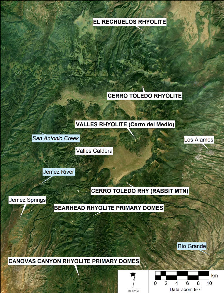
Supplemental Figure 2. Jemez Mountains Volcanic Field, northern New Mexico obsidian source locations (capitals) and significant features
Keres Group Obsidian
The Keres Group obsidian sources in the pre-caldera Jemez Mountains are the oldest artifact quality sources in the Jemez, including Canovas Canyon Rhyolite, also called Bear Springs Peak obsidian part of the older group dated most recently to between 8.81±0.16 Ma and 9.75±0.08 Ma (Kempter et al., 2004). Older dates between 9 and 12 Ma were reported by (Goff et al., 1990), and Bearhead Rhyolite was dated at the primary dome (F04-31) to 7.62±0.44 Ma (Goff et al. 2006; Kelley et al. 2013; Shackley et al., 2016). A sample of Canovas Canyon Rhyolite obsidian was recovered mixed in and above the Peralta Tuff with Bearhead Rhyolite above Paliza Canyon indicating the relatively similar age between these two rhyolites, and so the latter dates reported by Kempter et al. (2004) are accepted here (Shackley et al. 2016).
Canovas Canyon Rhyolite. Canovas Canyon Rhyolite obsidian, also called Bear Springs Peak in the archaeological literature, as mentioned above, is the oldest Jemez Mountains archaeological obsidian source at well over 8 Ma (Goff et al., 2006; Kelley et al., 2013; Kempter et al., 2004; Shackley, 2005, 2009). These pre-caldera domes appear to be overlain by a rhyolite tuff, but field inspection suggests to Kempter et al., (2004) that they are contemporaneous. Our work at Bear Springs Peak and dome structures to the north suggest that the obsidian was produced from obsidian zones on the margins of the domes as part of a lava producing eruptive event. The glassy lava has mostly devitrified into perlite, leaving the most vitreous and non-hydrated portions of the flow as remnant marekanites. Located at the far southern end of the Jemez Mountains just north and west of Jemez (Walatowa) Pueblo Nation land, this Neogene period source exhibits only relatively small marekanites now, most smaller than 2 cm in diameter. Although the nodule size was apparently small, Bear Springs Peak obsidian was used in prehistory as a tool stone and was recovered in samples analyzed from early historic period contexts at Zuni Pueblo, probably a result of relationships between the Zuni and Jemez in the 16th and 17th centuries (see Howell and Shackley, 2003; Shackley 2005, 102-105). The source data, as analyzed by Craig Skinner at the Northwest Research Obsidian Lab and this lab, suggest that this may be the "Bland Canyon & Apache Tears" source as reported by Glascock et al., (1999, 863), collected and reported by Wolfman (1994), and reported as "Canovas Canyon" by Church (2000) in his study of secondary deposits in the lower Rio Grande. Biotite in the crystalline rhyolite that underlies the obsidian zone yielded 40Ar/39Ar dates of 8.81±0.16 and 9.75±0.08 Ma (Kempter et al., 2004). Nodules up to 5 cm (rarely) occur as remnants in the perlite and given the presence of this source in Rio Grande alluvium at least as far south as Las Cruces, New Mexico over 350 km south, nodule sizes in the past were likely relatively larger given Neogene and Quaternary stream dynamics (Data table here).
Bearhead Rhyolite. For many years, Bearhead Rhyolite obsidian, previously known as Paliza Canyon was described and the elemental composition derived from four samples collected from Paliza Canyon (Vallecito Creek) alluvium based on Baugh and Nelson's examination of New Mexico obsidian sources (1987; see also Nelson, 1984). The Keres Group rhyolites, particularly Bearhead are distinctive in the Jemez Mountains sources by relatively high Sr and Ba, so even though for decades Bearhead Rhyolite was known mainly from the composition of those four samples, they were quite compositionally distinct enough to instill some confidence in source assignment. Given the lack of knowledge of the geological origin of this source, Shackley et al., (2016) examined the tuff in and above Paliza Canyon and Fraser Goff discovered at least one of the primary lava sources in a dome complex directly above Paliza Canyon eroding south and west through Vallecito Creek and ultimately for the last 7+ Ma eroding nearly 400 km south as far as Las Cruces (Church, 2000; Goff et al., 2006; Shackley et al., 2016). One obsidian marekanite from that dome F04-31 discovered by Fraser Goff in 2004 was dated by 40Ar/39Ar to 7.62±0.44 Ma (Goff et al., 2006; Kelley et al., 2013; Shackley et al., 2016) commensurate with other dating of Bearhead Rhyolite (Justet, 1999; Justet and Spell, 2001; Kempter et al., 2004). Now 61 obsidian samples have been analyzed from Bearhead Rhyolite, and unlike the earlier Canovas Canyon Rhyolite obsidian nearby, the nodule sizes at Bearhead Rhyolite are considerably larger, up to 17 cm. as recovered, and many well over 5 cm (Shackley et al., 2016, Tables 2 and 3, pp. 58-59; ). However, it does appear that the volume of marekanites from Canovas Canyon in Rio Grande Quaternary alluvium is nearly four times greater in this study, so the contribution to secondary deposits in the Rio Grande is higher, although both sources are comparatively rare (see Church 2000; Data table here).
Polvadera Group
The Polvadera Group best exposed in the northern Jemez Mountains, consists of three formations, oldest to youngest, Lobato basalt, Tschicoma Formation, and El Rechuelos Rhyolite (Goff and Gardner, 2004). The latter is the subject here. For years in the archaeological vernacular, the obsidian produced by El Rechuelos Rhyolite was called "Polvadera Peak" even though that peak is a dacite dome that did not produce obsidian.
El Rechuelos Rhyolite. El Rechuelos obsidian is derived from five small domes one west and four north of Polvadera Peak as originally noted by Baugh and Nelson (1987) and Wolfman (1994; see also Goff and Gardner, 2004; Konkright, 2019). Collections here were made at two to three small coalesced domes near the head of Cañada de los Ojitos and as secondary deposits in Cañada de los Ojitos (collection localities 080999-1&2). The center of the domes is located north of Polavadera Peak on the Polvadera Peak 7.5' quadrangle. The three domes are approximately 50 meters in diameter each and exhibit an ashy lava with rhyolite and aphyric obsidian nodules up to 15 cm in diameter, but dominated by nodules between 1 cm and 5 cm. Core fragments and primary and secondary flakes are common in the area.
Small nodules under 10-15 mm are also common in the alluvium throughout the area near Polvadera Peak, probably where the "Polvadera Peak" misnomer originated. Presumably they are remnants of various eruptive events associated with El Rechuelos Rhyolite. The samples analyzed, the results of which are available at http://swxrflab.net/jemez.htm#El%20Rechuelos are compositionally similar to the data presented in Baugh and Nelson (1987), Glascock et al., (1999), and Konkright (2019). El Rechuelos obsidian is generally very prominent in northern New Mexico archaeological collections from Paleoindian to historic periods, and present in all the collection areas except above the Puye Formation east of Cerro Toledo as expected (see Puye Formation discussion below). Although it is not distributed geologically over a large area, it is one of the finest raw materials for tool production in the Jemez Mountains. Its high quality as a toolstone probably explains its desirability in prehistory, particularly during the Archaic period. In nearly 500 nodules collected from the El Rechuelos area, few of the nodules exhibited spherulites or phenocrysts in the fabric, unlike much of Cerro Toledo and Valles Rhyolite obsidian. Additionally, El Rechuelos glass is megascopically distinctive from the other two major sources in the Jemez Mountains. It is uniformly micro-granular in character, apparently from ash incorporated into the matrix during the eruptive event. Cerro Toledo and Valles Rhyolite glass is generally not granular and more vitreous.
El Rechuelos obsidian dates by K/Ar to 2.02 to 2.07 Ma, and from that time has been eroding north into the Rio Chama, and into the Rio Grande above Española (Dalrymple et al., 1967; Loeffler et al., 1988). More recently Konkright re-dated much of the El Rechuelos Rhyolite by 40Ar/39Ar and concluded that "these seven units represent five separate eruptive episodes", divided into early, middle and late, but based on field relations, optical petrography, elemental, and isotopic analyses only the latest (2.23 ± 0.15 Ma) should be called El Rechuelos Rhyolite, the event that produced artifact quality obsidian (2019, iv, 89-92). El Rechuelos Rhyolite obsidian erodes through the Polvadera and Cañada de los Ojitos drainages north into the Rio Chama and then south into the Rio Grande. The proportion of El Rechuelos obsidian recovered in Rio Grande alluvium at least as far as Las Cruces indicates that the sediment load through the Rio Chama and into the Rio Grande from this source has been substantial over time (see Data table here).
Tewa Group Obsidian
Griggs (1964), Bailey et al., (1969), Smith et al., (1970), and Gardner et. al. (1986) have characterized the Tewa Group from the oldest to the youngest formations - Bandelier Tuff, Cerro Toledo Rhyolite, Cerro Rubio Quartz Latite, and Valles Rhyolite. The group consists almost entirely of rhyolite, and for geoarchaeological purposes Cerro Toledo Rhyolite and Valles Rhyolite are volumetrically the most common archaeological obsidian used throughout prehistory in much of the Southwest, as evident both archaeologically and in Rio Grande secondary deposits and dominate obsidian studies in New Mexico (Mills et al. 2013; Shackley, 2005). The Group deposits "unconformably blanket or intrude most older volcanic units within the Toledo and Valles calderas...and on the plateaus that flank the east, west, and north sides of the Jemez Mountains" (Gardner et al. 1986:1774). The Valles Caldera is so topographically prominent that it is easily seen from space (Goff et al. 2011; see Supplemental Figure 2 herein). A number of times when I have been working in and around the caldera I have met members of geology field camps and other groups visiting and studying this tremendous geological feature. The magma chamber under the Jemez Mountains, as at Yellowstone, is still quite hot, and could very likely perform another eruptive miracle in the future, when is unknown.
Cerro Toledo Rhyolite. Known in the archaeological vernacular incorrectly as "Obsidian Ridge" obsidian, Cerro Toldedo Rhyolite obsidian is derived from the Cerro Toledo Rhyolite eruptions (Bailey et al., 1969; Baugh and Nelson, 1987; Gardner et al., 1986; Goff et al., 2011; Heiken et al., 1986; Self et al., 1986; Smith et al., 1970; Spell et al., 1996). This is the most common secondary deposit obsidian in Quaternary alluvium along the entire length of the Rio Grande in New Mexico, and presumably south as shown here.
There were six pyroclastic eruptive events associated with the Cerro Toledo Rhyolite:
All tuff sequences from Toledo intracaldera activity are separated by epiclastic sedimentary rocks that represent periods of erosion and deposition in channels, important in this study. All consist of rhyolitic tephra and most contain Plinian pumice falls and thin beds of very fine grained ash of phreatomagmatic origin. Most Toledo deposits are thickest in paleocanyons cut into lower Bandelier Tuff and older rocks [as with the Rabbit Mountain ash flow]. Some of the phreatomagmatic tephra flowed down canyons from the caldera as base surges (Heiken et al. 1986:1802; brackets mine).
Two major ash flows are relevant here, separate from the Bandelier Tuff events (Goff and Gardner 2004). Weighted mean of 40Ar/39Ar dates from Spell et al. (1996) of the Cerro Toledo multiple events is from 1.54 ± 0.02 to 1.26 ± 0.01 Ma. One ash flow derived from what is now called the Toledo Embayment on the northeast side of the caldera is a 20 km wide band that trends to the northeast and is now highly eroded and interbedded in places with the upper levels of the earlier Puye Formation from around Guaje Mountain north to Santa Fe Forest Road 144 east of Española (Waresback and Turbeville 1990). This area has eroded rapidly and obsidian from this tuff is now an integral part of the Rio Grande alluvium north of Santa Fe, again relevant here. The other major ash flow is derived from the Rabbit Mountain portion of the Cerro Toledo event and is comprised of a southeast trending 4 km wide and 7 km long "tuff blanket" interbedded with a rhyolite breccia three to six meters thick that contains abundant obsidian erupted as lapilli during the Rabbit Mountain ash flow (Heiken et al. 1986). All of this is still eroding into the southeast trending canyons toward the Rio Grande and has been for over one million years. The surge deposits immediately south of Rabbit Mountain contain abundant obsidian chemically identical, at least when analyzed by XRF, to the samples from the ridges farther south and in the Rio Grande alluvium, as well as in sediments above the Puye Formation between Española and the Toledo Embayment (Shackley, 2005; see Puye Formation discussion in main text). Heiken et al's. NAA analysis of Rabbit Mountain lavas is very similar to those from this study (1986:1810; c.f. Spell et al. 1996; Glascock et al. 1999; see here).
While Obsidian Ridge has received all the archaeological "press" as the source of obsidian from Cerro Toledo Rhyolite on the southern edge of the caldera, the density of nodules and nodule sizes on ridges to the west is greater by a factor of two or more. All these ridges, of course, are remnants of the Rabbit Mountain ash flow and base surge, and the depth of canyons like Cochiti Canyon is a result of the loosely compacted tephra that comprises this plateau. At Locality 081199-1, nodules on the ridge top are up to 200 per m2 with over half that number of cores and flakes, comparable to the "monster quarry" on top of Cerro del Medio (Ana Steffen, personal communication, 2006; see images at http://swxrflab.net/jemez.htm). This density of nodules and artifacts forms a discontinuous distribution all the way to Rabbit Mountain. The discontinuity is probably due to cooling dynamics and/or subsequent colluviation. Where high density obsidian is exposed, prehistoric production and procurement is evident. At the base of Rabbit Mountain the density is about 1/8 that of Locality 081199-1, and south of this locality the density falls off rapidly. At Locality 081199-1 nodules range from pea gravel to 16 cm in diameter. Flake sizes suggest that 10 cm size nodules were typical in prehistory. Nodule sizes at Rabbit Mountain are up to 30 cm or more, reflected in the nodule sizes in Rio Grande alluvium particularly at Cochiti and Tijeras Wash (see main text; Rory Gauthier, personal communication, 2006).
Cerro Toledo Rhyolite obsidian both from the northern domes along the scarp of the Toledo Embayment and Rabbit Mountain varies from an excellent aphyric translucent brown glass to glass with large devitrified spherulites that make productive knapping nearly impossible. This character of the fabric is probably why there is so much test knapping at the sources – a need to determine the quality of the nodules before transport. While spherulitic fabric occurs in most of the Jemez Mountain obsidian, it seems to be most common in the Cerro Toledo glass and may explain why Valles Rhyolite (Cerro del Medio) obsidian occurs in sites a considerable distance from the caldera even though it is not secondarily distributed outside the caldera in any quantity while Cerro Toledo obsidian is common throughout the Rio Grande alluvium as seen in this study (Church 2000; Shackley 2005). Indeed, in Folsom period contexts in the Albuquerque basin, only Valles Rhyolite obsidian was selected for obsidian tool production even though Cerro Toledo obsidian is available almost on-site in areas such as the West Mesa of Albuquerque (Huckell et al. 2012; LeTourneau et al. 1996; Shackley 2010). So, while Cerro Toledo Rhyolite obsidian is and was numerically superior in the Rio Grande Basin, it wasn’t necessarily the preferred raw material in all time periods and archaeological contexts, all things being equal.
Valles Rhyolite (Cerro del Medio). In 1956 two geology graduate students from the University of New Mexico published the first paper on archaeological obsidian in the American Southwest, a refractive index analysis (Boyer and Robinson 1956). In this examination of the Jemez Mountain sources, they noted that obsidian did not occur in the alluvium of San Antonio Creek where it crosses New Mexico State Highway 126, but did occur "in pieces as large as hen’s eggs, but the material is not plentiful and must be searched for with care" in the East Jemez River alluvium where it crosses State Highway 4 (Boyer and Robinson 1956:336). A return to the latter locality (Locality 102799-2) exhibited about the same scenario as that recorded 43 years earlier. The East Jemez River alluvium exhibits nodules up to 40 mm in diameter at a density up to 5/m2, but generally much lower. Boyer and Robinson did find nodules up to 15.5 cm in diameter along the upper reaches of San Antonio Creek as shown in their plate (Boyer and Robinson 1956:337).
My survey along San Antonio Creek from its junction with New Mexico State Highway 126 for two miles upstream did not reveal any obsidian, as in the Boyer and Robinson study (see Supplemental Figure 2). It appears then that Valles Rhyolite obsidian does not enter secondary contexts outside the caldera, at least in nodules of any size compared to Cerro Toledo Rhyolite as evident along the Rio Grande in this study (see Church 2000). In 2018 Valles Rhyolite (Cerro del Medio) obsidian was recovered in Jemez River alluvium just north of the north Jemez tribal boundary, but the nodule sizes were less than 30 mm in diameter.
Valles Rhyolite obsidian exhibits a fabric that seems to be a combination of El Rechuelos and Cerro Toledo. Some of the glass has that granular texture of El Rechuelos and some has devitrified spherulites similar to Cerro Toledo, and much of it is aphyric black glass. Flakes of Valles Rhyolite obsidian can be indistinguishable from El Rechuelos or Cerro Toledo in hand sample. On the west slope of Cerro del Medio is an outcrop of artifact quality mahogany colored obsidian (Ana Steffen, personal communication, 2010). The elemental composition by XRF is the same as the dominant black variety (see Data table here).
Volumetrically the obsidian from Cerro del Medio (the other domes along the ring fracture did not produce artifact quality obsidian) is by far the highest in the U.S. Southwest, perhaps only approached by Government Mountain in the San Francisco volcanic field of northern Arizona (Shackley 1988, 1995, 2005). Boulders meters across still occur on the slopes of Cerro del Medio, and the "monster quarry" near the top of the peak still exhibits cobbles of obsidian 20-30 cm in diameter, and prehistoric reduction debris up to 50 cm thick in places with large biface preforms present on the surface. As mentioned above, even though Cerro Toledo Rhyolite through the Plinian eruptive event scattering obsidian southeast of the caldera for one million years is dominant in Rio Grande alluvium, Valles Rhyolite (Cerro del Medio) is archaeological distributed through at least 12 U.S. and Mexican states and as far east as at least Mississippi and west to California, as noted above (Steffen 2016).
The Valles Rhyolite event occurred after the Cerro Toldedo event, but has "presented challenges for radiometric dating" partly due to multiple smaller events at Cerro del Medio, with what appears to be about 50 to 80 ka of eruptions, many of those producing artifact quality obsidian (Gardner et al. 2007:368). Dates by 40Ar/39Ar range between 1.161 ± 0.01 to 1.229 ± 0.017 Ma (Gardner et al. 2007; Phillips 2004). The elemental composition of the smaller events at Cerro del Medio are not different as detectable by ICPMS or XRF, and the analyses of various portions of the dome or secondary deposits along San Antonio Creek or the East Jemez River are statistically similar (Gardner et al. 2007:370; see http://swxrflab.net/jemez.htm#Valle%20Grande%20Rhyolite).
While some Cerro del Medio obsidian is available in secondary deposits down the Jemez River at least as far as Jemez Nation land, the major reason that Cerro del Medio obsidian is rare in secondary deposits outside the caldera is that the event did not produce the large scale Plinian ash flows that Cerro Toledo Rhyolite did earlier. Generally, when Valles Rhyolite (Cerro del Medio) obsidian is recovered archaeologically, even nearby the caldera, it most likely was originally procured at the dome proper as seen by the large quantity of prehistoric reduction debris throughout the surface of the dome and surrounding alluvium, probably throughout prehistory by many groups when visiting the Jemez Mountains for a variety of purposes (Moore et al. 2020; Shackley and Moore 2018).
MOUNT TAYLOR VOLCANIC FIELD: GRANTS RIDGE AND HORACE/LA JARA MESAS
The Mount Taylor volcanic field as a Jemez Lineament field along with the Jemez Mountains is one of the most researched volcanic fields in New Mexico (see Goff et al. 2019). While the largest event was the Mount Taylor stratovolcano eruption, the earlier rhyolite episodes, called the Grants Ridge rhyolite center is of interest here (Goff et al. 2008, 2019; Shackley 1998, 2005). The Grants Ridge rhyolite center is "an impressive north-east trending exposure of silicic lava, with associated obsidian and tuffs" that towers over the landscape second only to the Mount Taylor stratovolcano (Goff et al. 2019:17). The obsidian from this source group has been called simply "Grants Ridge or East Grants Ridge" in the archaeological vernacular for decades (Baugh and Nelson 1987; Stevenson and McCurry 1990). In the late 1990s Shackley investigated the Grants Ridge source, and found that as noted by Goff et al. (2008) it was essentially a single event differentiated by obsidian produced in perlitic lava as on Grants Ridge proper, and produced from rapid quenching in an ash flow tuff (ignimbrite) event, much of the latter underlying Horace and La Jara Mesas (see Supplemental Figure 3). Stimulated by seemingly two elemental modalities, the 1998 study found that the Horace/La Jara Mesa obsidian was not only elementally distinct from the Grants Ridge locality glass, but unlike the Grants Ridge somewhat vitrophyric obsidian, was aphyric, and often a preferred tool stone in archaeological contexts in the region (Shackley 1998, 2005). Geologically Goff and others found this discrimination of minor importance, but geoarchaeologically discriminating these two sub-sources was of some value (see Supplemental Figure 4). Nodule sizes at Grants Ridge are up to at least 13 cm, but some nodules have been recovered on Horace Mesa over 10 cm, although the vast majority on Horace and La Jara Mesas are half that size. (Shackley 1998). There are slight differences in the eruptive periods between Grants Ridge and the Horace/La Jara Mesa tuff event; 3.50 Ma for obsidian at Grants Ridge, and obsidian clasts from upper tuff beds beneath La Jara Mesa have an Ar40/39 date of 3.26 ± 0.04 Ma, but allowing for statistical error, they are essentially the same (Goff et al. 2008, 2019; see also Lipman and Mehnert 1979). The Grants Ridge tuff called here the Horace/La Jara Mesa tuff/obsidian was possibly erupted in two separate events based on differences in Ar40/39 dates between the obsidian and sanidine derived from the tuff of about 0.32 Ma. (Goff et al. 2019:19). This may be evident with XRF analyses as seen in the plot in Supplemental Figure 4. Whether the trace element differentiation is due to fractionation from an evolving magma or some other issue is unknown, but the ability to discriminate the two sources Grants Ridge and Horace/La Jara Mesas has utility in archaeology (Data table here). Even though the Grants Ridge obsidian is sparsely porphyritic due mostly to small sanidine phenocrysts it was still used to produce chipped stone tools including relatively small late period arrowpoints.
As seen in this study, the secondary distribution of Mount Taylor obsidian is extensive (Shackley 1998). "Grants Ridge" obsidian has been reported to have eroded over the last 3+ million years into the Rio San Jose, then Rio Puerco and on into the Rio Grande (Gossett 1982; see also Church 2000). Both Grants Ridge and Horace/La Jara Mesa obsidian are present in Rio Grande Quaternary alluvium, but only after the Rio Puerco enters the Rio Grande just north of Socorro (see Table 1 and Figure 1 in main text). Both sources comprised 1.5% of the total in this study similar to Church's study at 1.6% farther south at Las Cruces (2000:664).
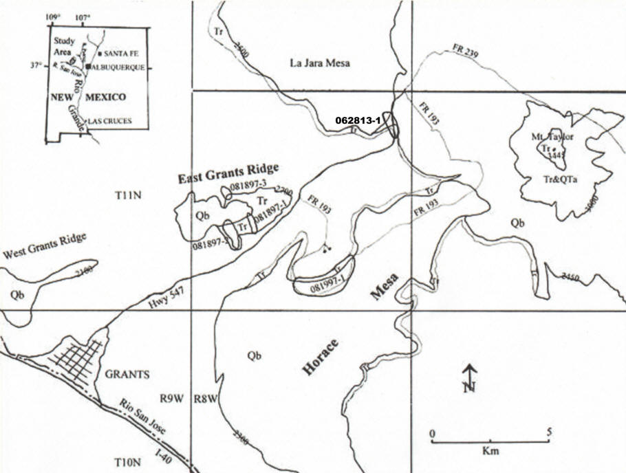
Supplemental Figure 3. The Mount Taylor Volcanic Field obsidian sources: Grants Ridge and Horace/La Jara Mesas (from Shackley 1998; see Goff et al. 2019).
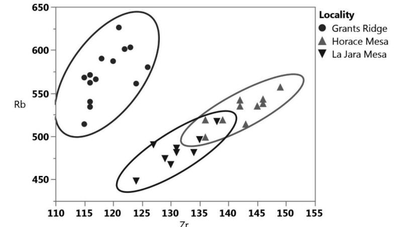
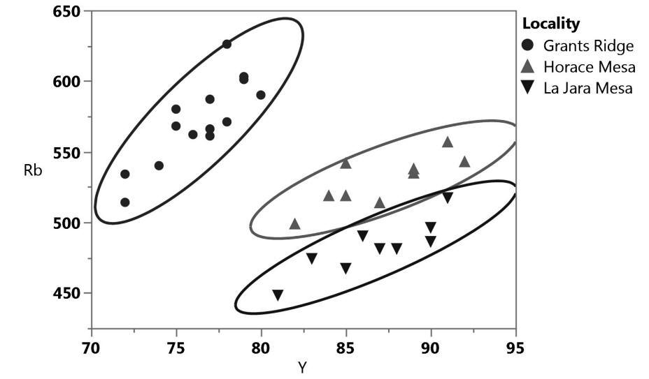
Supplemental Figure 4. Zr/Rb and Y/Rb bivariate plots of the Mount Taylor obsidian sources. Confidence ellipses at 95%.
REFERENCES CITED
Aldrich, M.J. (1986). Tectonics of the Jemez Lineament in the Jemez Mountains and Rio Grande rift. Journal of Geophysical Research 91:1753-1762.
Appelt, R.M. (1998). 40Ar/39Ar geochronology and volcanic evolution of the Taos Plateau Volcanic Field, northern New Mexico and southern Colorado. MS thesis, New Mexico Institute of Mining and Technology, Socorro, New Mexico.
Baker, I., and Ridley, W.I. (1970). Field evidence and K, Rb, Sr data bearing on the origin of Mt. Taylor volcanic field, New Mexico, U.S.A. Earth and Planetary Science Letters 10:106-114.
Bailey, R.A., Smith, R.L. and Ross, C.S. (1969). Stratigraphic nomenclature of volcanic rocks in the Jemez Mountains, New Mexico. U.S. Geological Survey Bulletin 1274-P:1-19.
Baugh, T.G. and Nelson, F.W. (1987). New Mexico obsidian sources and exchange on the Southern Plains. Journal of Field Archaeology 14:313-329.
Boyer, W.W., and Robinson, P. (1956). Obsidian artifacts of northwestern New Mexico and their correlation with source material. El Palacio 63:333-345.
Church, T. (2000). Distribution of sources of obsidian in the Rio Grande gravels of New Mexico. Geoarchaeology 15:649-678.
Dalrymple, G., Cox, A., Doell, R., and Grommé, C. (1967). Pliocene geomagnetic polarity epochs. Earth and Planetary Science Letters 2:163-173.
Ennis, D.J. (2011). Perlite mining and reclamation in the No Agua Peaks, Taos County, New Mexico. In D.J. Koning, K.E. Karlstrom, S.A. Kelley, V.W. Lueth, and S.B. Aby (Eds.), Geology of the Tusas Mountains and Ojo Caliente (pp.409-418). Socorro: New Mexico Geological Society 62nd Annual Fall Field Conference Guidebook.
Gardner, J.N., Goff, F., Garcia, F., and Hagan, R. (1986). Stratigraphic relations and lithologic variations in the Jemez Volcanic Field, New Mexico. Journal of Geophysical Research 91, B2:1763-1778.
Gardner, J.M., Sandoval, M.M., Goff, F., Phillips, E., and Dickens, A. (2007). Geology of the Cerro del Medio moat rhyolite center, Valles Caldera, New Mexico. In B.S. Kues, S.A. Kelley, and V.W. Lueth (Eds.) Geology of the Jemez Region II (pp. 367-372.). Socorro, New Mexico: New Mexico Geological Society 58th Annual Field Conference, New Mexico Geological Society.
Glascock, M.D., Kunselman, R., and Wolman, D. (1999). Intrasource chemical differentiation of obsidian in the Jemez Mountains and Taos Plateau, New Mexico. Journal of Archaeological Science 26:861-868.
Goff, F., Gardner, J.N., and Valentine, G. (1990). Geology of St. Peters Dome area, Jemez Mountains, New Mexico. Socorro, New Mexico: New Mexico Bureau of Geology and Mineral Resources Geologic Map GM-69, Socorro.
Goff, F., Kues, B.S., Rogers, M.A., McFadden, L.D., and Gardner, J.N., Eds. (1996). The Jemez Mountains Region. New Mexico Geological Society 47th Annual Field Conference, Socorro, New Mexico.
Goff, F., and J.N. Gardner. (2004). Late Cenozoic geochronology of volcanism and mineralization in the Jemez Mountains and Valles Caldera, north central New Mexico. In G.H. Mack and K.A. Giles (Eds.) The Geology of New Mexico: A Geologic History (pp. 295-312). Socorro, New Mexico: New Mexico Geological Society Special Publication 11.
Goff, F., Gardner, J.N., Reneau, S.L., and Goff, C.J. (2006). Geology of the Redondo Peak 7.5 minute quadrangle, Sandoval County, New Mexico. Socorro, New Mexico: New Mexico Bureau of Geology and Mineral Resources Open-File Geologic Map OF-GM 111, scale 1:24,000.
Goff, F., S.A. Kelley, K. Ziegler, P. Drakos, and C. Goff (2008). Geologic Map of the Lobo Springs 7.5-Minute Quadrangle Map, Cibola County, New Mexico. New Mexico Bureau of Geology & Mineral Resources Open-File Geologic Map 181, 1:24,000, Socorro.
Goff, F., Gardner, J.N., Reneau, S.L., Kelley, S.A., Kempter, K.A., and Lawrence, J.R. (2011). Geologic map of the Valles caldera, Jemez Mountains, New Mexico. Geologic Map 79, Socorro, New Mexico: New Mexico Bureau of Geology and Mineral Resources, Socorro.
Goff, F. Kelley, S.A., Goff, C.J., McGraw, D.J., Osburn, G.R., Lawrence, J.R., Drakos, P.G., and Skotnicki, S.J. (2019). Geologic Map of the Mount Taylor Volcano Area, New Mexico. Geologic map 80. Socorro, New Mexico: New Mexico Bureau of Geology and Mineral Resources.
Griggs, R. (1964). Geology and groundwater resources of the Los Alamos area, New Mexico. U.S. Geological Survey Water Supply Paper 1753.
Heiken, G., Goff, F., Stix, J., Tamanyu, S., Shafiqullah, M., Garcia, S., and Hagan, R. (1986). Intercaldera volcanic activity, Toledo caldera and embayment, Jemez Mountains, New Mexico. Journal of Geophysical Research 91:1799-1815.
Howell, T.L., and Shackley, M.S. (2003). Investigating obsidian procurement at Zuni Pueblo. Report prepared for the Arizona Archaeological and Historical Society. Manuscript on file at Zuni Cultural Resource Enterprise, Zuni, New Mexico.
Justet, L. (1999). The Geochronology and Geochemistry of the Bearhead Rhyolite, Jemez Volcanic Field, New Mexico. MS thesis, University of Nevada, Las Vegas.
Justet, L., and Spell, T.L. (2001). Effusive eruptions from a large silicic magma chamber: the Bearhead Rhyolite, Jemez volcanic field, NM. Journal of Volcanology and Geothermal Research 107:241-264.
Kelley, S.A., McIntosh, W.C., Goff, F., Kempter, K.A., Wolff, J.A., Esser, R., Braschayko, S., Love, D., and Gardner, J.N. (2013). Spatial and temporal trends in pre-caldera Jemez Mountains volcanic and fault activity. Geosphere 9:614-646.
Kempter, K, Osburn, G.R., Kelley, S., Rampey, M., Ferguson, C., and Gardner, J. (2004). Preliminary geologic map of the Bear Springs Peak quadrangle, Sandoval County, New Mexico. Socorro, New Mexico: Bureau of Geology and Mineral Resources Open-file Digital Geologic Map OF-GM 74.
Konkright, K.J. (2019). Petrogenesis of the El Rechuelos Rhyolite, Jemez Mountains Volcanic Field, New Mexico, USA. MS thesis, Department of Geoscience, University of Nevada, Las Vegas.
Kues, B.S., Kelley, S.A., and Lueth, V.W., Eds. (2007). Geology of the Jemez Region II. New Mexico Geological Society 58th Annual Field Conference, Socorro, New Mexico.
Lipman, P.W., and Mehnert, H.H. (1979), The Taos Plateau volcanic field, northern Rio Grande rift, New Mexico. In Riecker, R.E. (Ed.) Rio Grande Rift: Tectonics and Magmatism (pp. 289-311). Washington, DC: American Geophysical Union.
LeTourneau, P.D., Shackley, M.S., Warnica, J.M., and Cummings, J. (1996). Analysis of obsidian Folsom artifacts from New Mexico. Current Research in the Pleistocene 13:59-61.
Loeffler, B., Vaniman, D. Baldridge, W., and Shafiqualla, M. (1988). Neogene rhyolites of the northern Jemez volcanic field, New Mexico. Journal of Geophysical Research 93:6157-6167.
Mills, B.J., Clark, JJ., Peeples, M.A., Haas, Jr., W.R., Roberts, Jr., J.M., Hill, J.B., Huntley, D.L. Borck, L., Breiger, R.L., Clauset, A., and Shackley M.S. (2013). Transformation of Social Networks in the Late Pre-Hispanic US Southwest. Proceedings of the National Academy of Science 110:5785-5790.
Moore, J.L., Blinman, E. and Shackley, M.S. (2020). Temporal variation in obsidian procurement in the northern Rio Grande and its implication for obsidian movement in the San Juan area. American Antiquity 85:152-170.
Naert, K.A., Wright, L.A., and Thornton, C.P. (1980). Geology of the perlite deposits of the No Agua Peaks, Taos County, New Mexico. Socorro, New Mexico: New Mexico Bureau of Mines and Mineral Resources Open-file Report 162.
Nelson, F.W. (1984). X-ray fluorescence analysis of some western North American Obsidian. In R.E. Hughes (Ed.) Obsidian Studies in the Great Basin (pp. 27-62). Berkeley, California: Contributions of the University of California Archaeological Research Facility 45.
Phillips, E.H. (2004). Collapse and resurgence of the Valles caldera, Jemez Mountains, New Mexico: age constraints on the timing and duration of resurgence and ages or megabreccia blocks. M.S. thesis, Department of Earth and Environmental Science, New Mexico Institute of Mining and Technology, Socorro.
Self, S., Goff, F., Gardner, J., Wright, J., and Kite, W. (1986). Explosive rhyolitic volcanism in the Jemez Mountains: vent locations, caldera development, and relation to regional structure. Journal of Geophysical Research 91:1779-1798.
Shackley, M.S. (1988). Sources of archaeological obsidian in the Southwest: an archaeological, petrological, and geochemical study. American Antiquity 53:752-772.
Shackley, M.S. (1995). Sources of archaeological obsidian in the greater American Southwest: an update and quantitative analysis. American Antiquity 60:531-551.
Shackley, M.S. (1998). Geochemical differentiation and prehistoric procurement of obsidian in the Mount Taylor Volcanic Field, northwest New Mexico. Journal of Archaeological Science 25:1073-1082.
Shackley, M.S. (2005). Obsidian: Geology and Archaeology in the North American Southwest. Tucson, Arizona: University of Arizona Press.
Shackley, M.S. (2009). Two newly discovered sources of archaeological obsidian in the Southwest: archaeological and social implications. Kiva, 74:269-280.
Shackley, M.S. (2010). Source provenance of Folsom point fragments and debitage from the Boca Negra Wash Site (LA 124474), West Mesa, Albuquerque, New Mexico. Report available at: https://escholarship.org/uc/item/82r1n03c
Shackley, M.S. (2018a). Source provenance of obsidian artifacts from Picuris Pueblo Convento, northern New Mexico. Report prepared for Tyler Michael, Department of Anthropology, Harvard University, Cambridge, Massachusetts. Report in possession of author.
Shackley, M.S., Goff, F., and Dolan, S.G. (2016). Geologic origin of the source of Bearhead Rhyolite (Paliza Canyon) obsidian, Jemez Mountains, northern New Mexico. New Mexico Geology 38:52-65.
Shackley, M.S., and Moore, J.L., (2018), More than just Jemez Pueblo obsidian: comment on Liebmann's "...Landscapes of Signification in the American Southwest". American Antiquity 83:753-755.
Smith, R.L., Bailey, R.A., and Ross, C.S. (1970). Geologic map of the Jemez Mountains, New Mexico. Reston, Virginia: U.S. Geological Survey, Miscellaneous Geologic Investigations Map I-571.
Spell, T.L., Kyle, P.R., and Baker, J. (1996). Geochronology and geochemistry of the Cerro Toledo Rhyolite. In Goff, F., Kues, B.S., Rogers, M.A., McFadden, L.D., and Gardner, J.N. (Eds.) The Jemez Mountains Region, (pp. 263-268). Socorro, New Mexico: New Mexico Geological Society 47th Annual Field Conference.
Steffen, A. (2016). The high-elevation archaeological record of the Valles Caldera. Archaeology Southwest 30:9-12.
Stevenson, C.M. and McCurry, M.O. (1990). Chemical characterization and hydration rate development for New Mexico obsidian sources. Geoarchaeology 5:149-170.
Whitson, D. (1982). Geology of the No Agua deposit at No Agua Peaks, New Mexico. In G.S. Austin (compiler) Industrial Rocks and Minerals of the Southwest (pp. 89-95). Socorro, New Mexico: New Mexico Bureau of Mines and Mineral Resources Circular.
Wolfman, D. (1993). Jemez Mountains Chronology Study. Report prepared for the Office of Archaeological Studies, Museum of New Mexico and the USDA National Forest Service. Manuscript available at Santa Fe National Forest, Santa Fe, New Mexico.