BULL CREEK (FORMERLY AZ UNKNOWN B), YAVAPAI COUNTY, WESTERN ARIZONA, USA
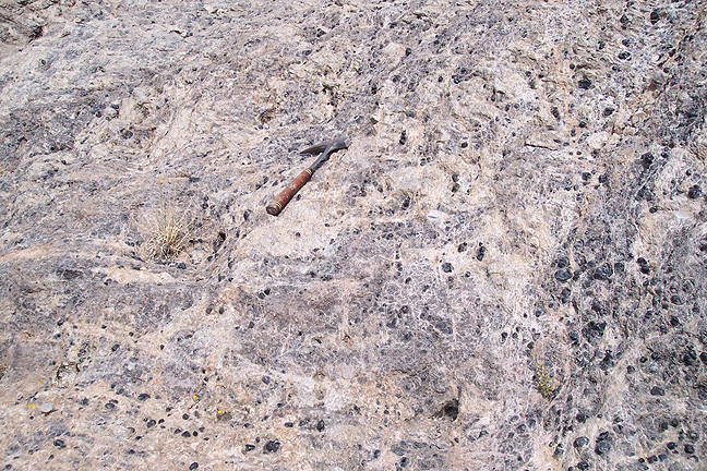
Perlitic lava with remnant marekanites at Bull Creek.
Over the years, all volcanic fields in the area have been investigated. On 11 and 12 July 1999 the sediments east between I-17 and the Agua Fria River along Bloody Basin Road southeast of Codes Junction, and the Agua Fria upstream from this area north of Mayer were surveyed for obsidian in the alluvium. None was found. While no rhyolite is mapped in this area on the Yavapai County geological sheet (Arizona Bureau of Mines 1958), this is not unusual at that scale. Both andesite and basalt are mapped in the area indicating the possibility of bimodal volcanism, which is common in the Basin and Range complex and frequently includes Tertiary silicic volcanism as an early phase in the eruptive history (Shackley 2005).
Discovered only in 2003 by John Rose (U.S. Bureau of Land Management, Kingman) and a crew from Pima Community College, this source called Bull Creek is located just south of the Burro Complex as detailed by Moyer (1982, 1986; see also Shackley 1988, 1995, 2005), and has the same elemental composition of AZ Unknown B, and so can be considered “discovered” (Figure 1). The exact location is not given here since it is an archaeological site on federal property.
Gifford and his Yavapai consultant could very likely have confused “Walnut Grove” and “Walnut Creek”, but the mention of a “cave” where obsidian was procured is interesting given the presence of a rockshelter with groundstone and ceramics at Bull Creek that has marekanites in the perlitic lava walls. We’ll probably never know if this is the source that Gifford’s Yavapai informant was talking about.
The site was mapped and sampled by me and archaeologists from Pima Community College in October 2003. Interestingly, while the secondary distribution down Bull Creek and north to Burro Creek is not as extensive as Burro Creek, it appears to be more commonly used in prehistory, although there has been so little archaeological work in this part of western Arizona that this could be sampling error. Two small marekanites of Bull Creek were found in a site recorded by SWCA in 2003 in the Juniper Mountains north of Prescott only about 32 linear km east of Bull Creek.
Bull Creek’s geology seems quite similar to the rhyolite of the Burro Complex and may very well be contemporaneous (Tertiary), or actually part of the complex, although the elemental composition is quite different from the Burro Creek obsidian (Shackley 1995, 2005; Figures 2 and 3 here). The source outcrops at a number of rhyolite domes at the head of Bull Creek in western Yavapai County, north of Bagdad and just below Bozarth Mesa. The elemental analysis was performed on samples derived from two separate domes (Table 1). It’s location near high prehistoric site density on the piñon-juniper grasslands of Bozarth Mesa may be responsible for it’s more common use in prehistory as opposed to Burro Creek in a slightly more arid region. Based on the presence of AZ Unknown B, this source is present at least as far east as Mayer over 95 km southeast in central Arizona and is common in sites in the Prescott area.
Marekanites up to 10 cm in diameter are present in both perlitic and ashy lava on a number of domes at the head of Bull Creek in a geologic environment quite similar to Sand Tanks to the south in west Maricopa County (Shackley and Tucker 2001). Most marekanites are less than 2 cm, and bipolar cores and flakes are common on the surface of the perlitic lava up to a density of 10/100m2. Chalcedony flakes derived from precipitation through the rhyolite also occurs.
While the marekanites have been eroding down Bull Creek and ultimately into Burro Creek, the analysis of nodules collected from Burro Creek over the years has not detected this source, suggesting that few actually reach this far west. Although the Burro Creek has been known to rockhounds and collectors for many years, it is practically absent in archaeological contexts in Arizona, while Bull Creek is commonly found in the region, despite the similar quality for tool production. The discovery of this source solves a long term “unknown source” in the North American Southwest.
REFERENCES CITED
Arizona Bureau of Mines
1958 Geologic Map of Yavapai County. Arizona Bureau of Mines, University of Arizona.
Gifford, E.W.
1936 Northeastern and Western Yavapai. University of California Publications in American Archaeology and Ethnology 34(1):247-354. Berkeley.
Moyer, Thomas C.
1982 The Volcanic Geology of the Kaiser Spring Area, SE Mohave County,
Arizona. Master's Thesis,
Department of Geology, Arizona State University.
1986 The Pliocene Kaiser Spring (AZ) Bimodal Volcanic Field: Geology, Geochemistry, and Petrogenesis. Ph.D. dissertation, Department of Geology, Arizona State University.
Shackley, M.S.
1988 Sources of Archaeological Obsidian in the Southwest: An Archaeological, Petrological, and Geochemical Study. American Antiquity 53:752-772.
1995 Sources of Archaeological Obsidian in the Greater American Southwest: An Update and Quantitative Analysis. American Antiquity 60:531-551.
1996 An Energy-Dispersive X-Ray Fluorescence (EDXRF) Analysis of Obsidian Artifacts from AZ N:12:14, 22, 57 (ASM), near Mayer, Arizona. Report prepared for Archaeological Consulting Services, Tempe, Arizona.
2005 Obsidian: Geology and Archaeology in the North American Southwest. University of Arizona Press, Tucson.
Shackley, M.S., and D.B. Tucker
2001 Limited Prehistoric Procurement of Sand Tank Obsidian, Southwestern Arizona. Kiva 66:345-374.
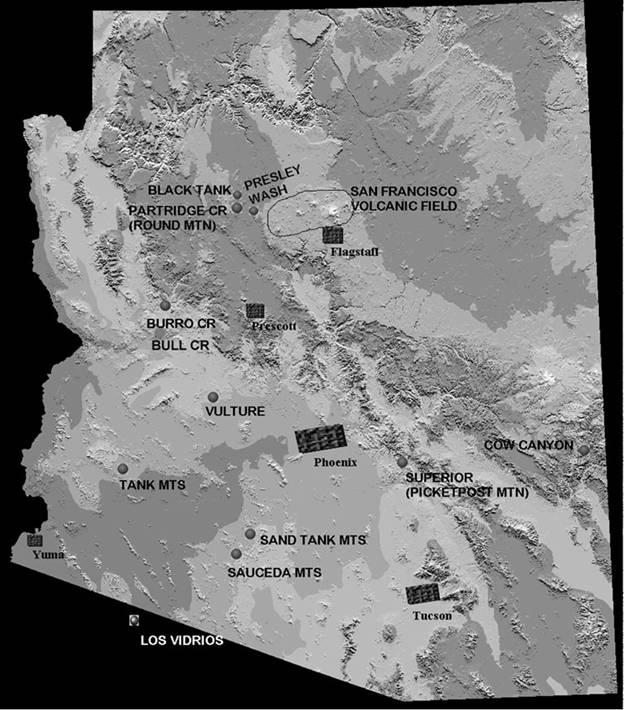
Figure 1. Sources of archaeological obsidian in Arizona. Bull Creek is located in western Arizona just south of the Burro Creek source.
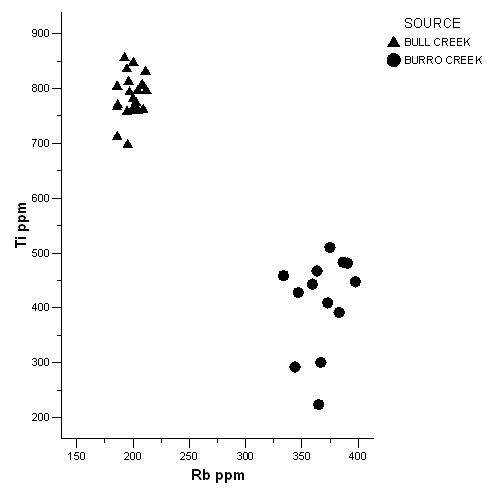
Figure 2. Biplot of Bull Creek and Burro Creek elemental concentrations for Ti and Rb.
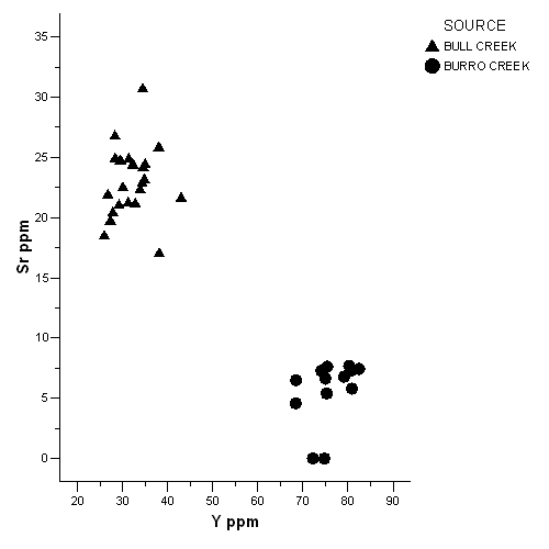
Figure 3. Biplot of Bull Creek and Burro Creek elemental concentrations for Sr and Y.
Table 1. Elemental concentrations for Bull Creek.
| Sample | Ti | Mn | Fe | Rb | Sr | Y | Zr | Nb | Th |
| 100603-2-1 | 796 | 530 | 7207 | 204 | 26 | 38 | 76 | 33 | 26 |
| 100603-2-2 | 781 | 479 | 6899 | 200 | 20 | 28 | 79 | 25 | 43 |
| 100603-2-3 | 775 | 526 | 7447 | 203 | 24 | 32 | 78 | 35 | 25 |
| 100603-2-4 | 813 | 436 | 6746 | 196 | 24 | 35 | 74 | 28 | 34 |
| 100603-2-5 | 759 | 454 | 7096 | 205 | 25 | 28 | 80 | 31 | 42 |
| 100603-2-6 | 847 | 489 | 6856 | 200 | 27 | 28 | 75 | 27 | 20 |
| 100603-2-7 | 831 | 500 | 7227 | 211 | 24 | 35 | 82 | 26 | 32 |
| 100603-2-8 | 760 | 525 | 7138 | 201 | 22 | 27 | 77 | 22 | 22 |
| 100603-2-9 | 712 | 452 | 6306 | 186 | 20 | 27 | 72 | 17 | 31 |
| 100603-2-10 | 793 | 464 | 6966 | 197 | 17 | 38 | 80 | 37 | 25 |
| 100603-2-11 | 766 | 397 | 6416 | 186 | 22 | 30 | 77 | 28 | 33 |
| 100603-2-12 | 835 | 461 | 7045 | 194 | 21 | 29 | 77 | 30 | 36 |
| 100603-2-13 | 856 | 475 | 6831 | 192 | 25 | 31 | 80 | 30 | 24 |
| 100603-2-14 | 698 | 476 | 7038 | 195 | 21 | 33 | 83 | 32 | 26 |
| 100603-2-15 | 758 | 436 | 6582 | 195 | 18 | 26 | 75 | 24 | 40 |
| 100603-2-16 | 761 | 485 | 7237 | 204 | 22 | 43 | 76 | 23 | 30 |
| 100603-2-17 | 804 | 490 | 7237 | 207 | 31 | 34 | 74 | 30 | 31 |
| 100603-2-18 | 764 | 500 | 7221 | 200 | 25 | 29 | 88 | 26 | 27 |
| 100603-2-19 | 804 | 481 | 6514 | 186 | 23 | 34 | 67 | 28 | 27 |
| 100603-2-20 | 770 | 420 | 6575 | 186 | 21 | 31 | 71 | 28 | 25 |
| Src-2-21 | 762 | 506 | 7466 | 209 | 24 | 32 | 76 | 34 | 48 |
| Src-2-22 | 796 | 537 | 7442 | 212 | 23 | 35 | 78 | 33 | 30 |
| Src-2-23 | 807 | 573 | 7571 | 208 | 22 | 34 | 76 | 29 | 20 |
Table 2. Selected elemental concentrations for Bull Creek, Arizona source standards.
|
Element |
N |
Minimum |
Maximum |
Mean |
Std. Deviation |
|
|
|
|
|
||
|
Ti |
23 |
698 |
856 |
698 |
39 |
|
Mn |
23 |
397 |
573 |
482 |
41 |
|
Fe |
23 |
6306 |
7571 |
7003 |
354 |
|
Rb |
23 |
186 |
212 |
199 |
8 |
|
Sr |
23 |
17 |
31 |
23 |
3 |
|
Y |
23 |
25 |
43 |
32 |
4 |
|
Zr |
23 |
67 |
88 |
77 |
4 |
|
Nb |
23 |
17 |
37 |
29 |
4 |
![]()
This page maintained by Steve Shackley (shackley@berkeley.edu).
Copyright © 2006 M. Steven Shackley. All rights reserved.
Revised:04 February 2017
![]() Back to
the SW obsidian source page.
Back to
the SW obsidian source page.
![]()