![]()
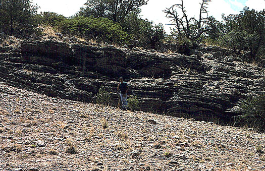
Perlitic lava dated to 19.56±0.04 Ma at the Antelope Creek East locality of the Mule Creek Regional Source, western New Mexico
Mule Creek Caldera and Ash-flow Sheet
Collections from: Sections 1,2,3,10,11,12 R21W, T14S; Sections 5,6 R20W, T14S USGS Mule Creek 7.5' Quad, Gila National Forest, Grant County, New Mexico; and a road cut at the junction of AZ Hwy 78 and Coal Canyon R32E, T14S (no sections delimited), Greenlee County, Arizona.
Mule Creek is probably the geographically largest obsidian source in the Southwest. The obsidian is found in a very extensive late Tertiary ash-flow sheet that covers portions of Greenlee County, Arizona, Catron and Grants Counties, New Mexico and may extend over to the Mogollon Mountains to the east (see Gwynn Canyon source below) (Rhodes and Smith 1972; Weber and Willard 1959). The nodules, up to 10 cm in diameter, may have been pyroclasts within the large ash flow. The nodule density in some areas reaches 100 per 5m2, especially on the top of the ash hills. Erosion into the San Francisco and Gila River systems is very possible.
The aphyric glass ranges from opaque black to translucent smoky gray with some gray banding. In 200 specimens collected, three are mahogany-brown and black banded similar to Slate Mountain (Wallace Tank) material. Some of the cortex exhibits a silver sheen, but most is a thin black-brown. The material from the east locality is a fair medium for tool production, but is very brittle much like Los Vidrios. The pressure reduction potential is, however, very good.
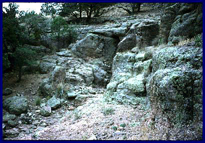
Marekanites in perlitic lava matrix at the Antelope Creek East locality (shown above) New Mexico
New images from October 2008:
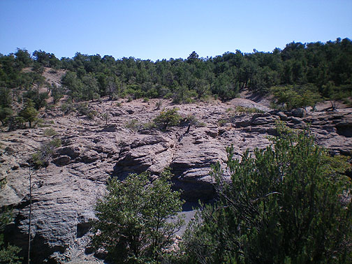
Large perlitic "obsidian zone" east of the area shown above. Marekanites common throughout this perlitic lava. Marekanites from this area are eroding into Antelope Creek, Harden Cienga Creek and into the San Francisco River, and west into the Gila River.
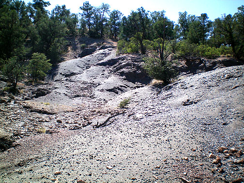
High marekanite density in region shown in image above. Dark dots in foreground are marekanites.
The overall density of obsidian flakes and cores was relatively low (<1 per 20 m2), probably due to the sheer extent of the deposit. A few rejected biface fragments (laterally fractured) and utilized flakes (<10) were recorded. Published references include Findlow and Bolognese (1982a and 1982b), Rhodes and Smith (1972), and Weber and Willard (1959).
Updated 1995: One of the most startling recent discoveries is the chemical variability in the Mule Creek obsidian. In the earlier study, I noted two "outliers" collected at Mule Creek with significantly higher rubidium concentration values (Shackley 1988:767). These outliers have now been identified as a distinct chemical group, often mixed in the regional Gila Conglomerate with three other chemical groups. The geology in the area is complex and has been studied by Ratté, and others for some time (Brooks and Ratté 1985; Ratté 1982; Ratté and Brooks 1983, 1989; Ratté and Hedlund 1981; Rhodes and Smith 1972). Primary in situ perlite localities for three of the chemical groups have been located.
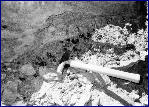
Ashy, perlitic lava at the Mule Mountain Locality
At least four distinct chemical groups are evident, distinguished by Rb, Y, Nb, and Ba, and a lesser extent Sr, and Zr concentration values, and are named after the localities where marekanites have been found in perlitic lava: Antelope Creek; Mule Mountains; and Mule Creek/North Sawmill Creek all in New Mexico. Additionally, during the 1994 field season, a fourth sub-group was discovered in the San Francisco River alluvium near Clifton, Arizona and in older alluvium between Highway 191 and Eagle Creek in eastern Arizona north of Clifton. While in situ nodules have not yet been found they are certainly located somewhere west of Blue River and north and west of the San Francisco River since none of this `low zirconium' sub-group was discovered in alluvium upstream from the juncture of the Blue and San Francisco Rivers. The genetic relationship is apparent in the trace element matrix plot (Shackley 1995:Figure 2), and signifies the very complex nature of the Mule Creek silicic geology, with subsequent depositional mixing in the Gila Conglomerate. Glass at other Tertiary sources in the Southwest, such as Sauceda Mountains and Antelope Wells, also appear to exhibit more than one chemical mode, although not as distinct as Mule Creek (LeTourneau 1994; Shackley 2005). The Mule Creek case is unusual because the chemical groups are not always spatially discrete and occur together in the extensive Gila Conglomerate which is mainly composed of Mule Creek rhyolite and tuffs in the area where the marekanites do occur (see Ratté and Brooks 1989). After fieldwork in 2009 it appears that the North Sawmill Creek chemical group extends within the Gila Conglomerate nearly to the Arizona state line.
Updated June and September 2013: Another locality of Antelope Creek was investigated. This locality was discovered during the University of Arizona Field School's general survey of the area by Dan Welch one of the crew chiefs at the same time that the Keck Foundation Obsidian Field School was in the area. This locality is characterized as a regolith containing rhyolite lava, dacite, and andesite with abundant obsidian marekanites that overlies an ash flow or ignimbrite at the head of Antelope Creek as it erodes north into Harden Cienega Creek and down into the San Francisco River, a completely different environment from the eastern locality characterized by a large perlitic dome complex with remnant marekanites. Located about 4 km directly west of the original eastern locality, the marekanites are an excellent vitreous media for tool production and many of the marekanites are well over 7 or 8 mm in diameter. The character of these marekanites is quite a bit better than the perlitic nodules at the eastern locality, even though the absolute number of nodules may be less. Consequently, the number of reduced cores and flakes is much higher at the western locality as would be expected with this better raw material. The megascopic character is also different. While there are many marekanites in the western locality that are nearly opaque like in the east, there are many that are nearly transparent, or at least more translucent. It is likely that the western locality is THE prehistoric source for Antelope Creek obsidian in the Southwest. The Y versus Nb plot below indicates that there is no significant difference in elemental chemistry between the two localities. See SPOT image below for relevant locations. Nodules up to 10 cm were discovered in Cienega Creek at the west locality.
Table 1. Elemental composition of Mogollon-Datil Volcanic Province obsidian sources. All measurements in parts per million (ppm).
| SOURCE/CHEMICAL GROUP | Mn | Rb | Sr | Y | Zr | Nb | Ba |
| MULE CREEK COMPLEX | |||||||
| Antelope Cr East | 334 | 241 | 19 | 39 | 130 | 25 | 126 |
| Antelope Cr East | 321 | 229 | 17 | 41 | 126 | 23 | 147 |
| Antelope Cr East | 347 | 230 | 18 | 39 | 128 | 27 | 125 |
| Antelope Cr East | 330 | 232 | 17 | 40 | 131 | 28 | 132 |
| Antelope Cr East | 368 | 236 | 16 | 40 | 131 | 29 | 133 |
| Antelope Cr East | 319 | 234 | 19 | 39 | 127 | 24 | 133 |
| Antelope Cr East | 392 | 247 | 17 | 42 | 130 | 26 | 133 |
| Antelope Cr East | 286 | 221 | 17 | 39 | 125 | 29 | 128 |
| Antelope Cr East | 329 | 242 | 17 | 44 | 130 | 27 | 107 |
| Antelope Cr East | 393 | 254 | 18 | 42 | 112 | 29 | 94 |
| Antelope Cr East | 425 | 272 | 16 | 43 | 121 | 26 | 85 |
| Antelope Cr East | 323 | 227 | 16 | 34 | 110 | 25 | 93 |
| Antelope Cr East | 356 | 242 | 17 | 44 | 114 | 23 | 89 |
| Antelope Cr East | 408 | 247 | 17 | 45 | 117 | 31 | 94 |
| Antelope Cr East | 377 | 252 | 14 | 42 | 120 | 23 | 83 |
| Antelope Cr East | 422 | 264 | 14 | 46 | 114 | 27 | 89 |
| Antelope Cr East | 410 | 265 | 12 | 45 | 119 | 24 | 79 |
| Antelope Cr East | 364 | 251 | 14 | 40 | 114 | 23 | 79 |
| Antelope Cr East | 369 | 265 | 15 | 41 | 116 | 30 | 82 |
| Antelope Cr East | 357 | 263 | 8 | 51 | 121 | 33 | 64 |
| Antelope Cr East | 384 | 254 | 10 | 47 | 116 | 32 | 64 |
| Antelope Cr West | 356 | 232 | 21 | 38 | 109 | 24 | 40 |
| Antelope Cr West | 343 | 224 | 21 | 39 | 110 | 27 | 48 |
| Antelope Cr West | 352 | 246 | 21 | 40 | 106 | 26 | 87 |
| Antelope Cr West | 348 | 241 | 18 | 42 | 113 | 27 | 33 |
| Antelope Cr West | 360 | 234 | 21 | 42 | 107 | 22 | 70 |
| Antelope Cr West | 377 | 238 | 19 | 43 | 111 | 26 | 34 |
| Antelope Cr West | 358 | 236 | 19 | 42 | 112 | 27 | 52 |
| Antelope Cr West | 352 | 241 | 21 | 44 | 114 | 25 | 43 |
| Antelope Cr West | 355 | 234 | 20 | 40 | 111 | 24 | 85 |
| Antelope Cr West | 331 | 221 | 20 | 41 | 106 | 26 | 62 |
| Antelope Cr West | 383 | 251 | 17 | 44 | 114 | 22 | 43 |
| Antelope Cr West | 402 | 260 | 21 | 43 | 110 | 29 | 33 |
| Antelope Cr West | 381 | 246 | 21 | 44 | 116 | 29 | 30 |
| Antelope Cr West | 372 | 239 | 24 | 43 | 112 | 29 | 54 |
| Mule Cr/N Sawmill Cr | 543 | 413 | 8 | 76 | 122 | 121 | 43 |
| Mule Cr/N Sawmill Cr | 524 | 399 | 4 | 71 | 119 | 117 | 43 |
| Mule Cr/N Sawmill Cr | 556 | 420 | 6 | 73 | 126 | 125 | 48 |
| Mule Cr/N Sawmill Cr | 538 | 397 | 8 | 69 | 119 | 116 | 46 |
| Mule Cr/N Sawmill Cr | 503 | 391 | 7 | 67 | 120 | 119 | 47 |
| Mule Cr/N Sawmill Cr | 519 | 387 | 7 | 69 | 121 | 117 | 44 |
| Mule Cr/N Sawmill Cr | 570 | 412 | 5 | 70 | 121 | 119 | 47 |
| Mule Cr/N Sawmill Cr | 672 | 403 | 10 | 71 | 125 | 120 | 45 |
| Mule Cr/N Sawmill Cr | 555 | 402 | 7 | 71 | 120 | 113 | 44 |
| Mule Cr/N Sawmill Cr | 558 | 409 | 6 | 70 | 122 | 124 | 44 |
| Mule Cr/N Sawmill Cr | 584 | 412 | 5 | 70 | 121 | 117 | 47 |
| Mule Cr/N Sawmill Cr | 588 | 431 | 6 | 70 | 123 | 121 | 43 |
| Mule Cr/N Sawmill Cr | 612 | 427 | 4 | 75 | 124 | 118 | 45 |
| Mule Cr/N Sawmill Cr | 549 | 410 | 5 | 73 | 124 | 117 | 46 |
| Mule Cr/N Sawmill Cr | 524 | 384 | 6 | 70 | 116 | 111 | 47 |
| Mule Cr/N Sawmill Cr | 550 | 417 | 7 | 69 | 122 | 121 | 45 |
| Mule Cr/N Sawmill Cr | 632 | 444 | 7 | 74 | 131 | 126 | 43 |
| Mule Cr/N Sawmill Cr | 588 | 433 | 5 | 74 | 129 | 123 | 50 |
| Mule Cr/N Sawmill Cr | 605 | 418 | 5 | 73 | 121 | 121 | 44 |
| Mule Cr/N Sawmill Cr | 539 | 390 | 3 | 69 | 115 | 115 | 46 |
| Mule Cr/N Sawmill Cr | 560 | 409 | 6 | 70 | 122 | 116 | 43 |
| Mule Cr/N Sawmill Cr | 565 | 406 | 7 | 71 | 119 | 120 | 45 |
| Mule Cr/N Sawmill Cr | 575 | 409 | 7 | 69 | 118 | 121 | 47 |
| Mule Cr/N Sawmill Cr | 550 | 414 | 4 | 72 | 124 | 120 | 46 |
| Mule Cr/N Sawmill Cr | 608 | 426 | 7 | 74 | 120 | 125 | 45 |
| Mule Cr/N Sawmill Cr | 523 | 393 | 6 | 71 | 119 | 120 | 47 |
| Mule Cr/N Sawmill Cr | 603 | 423 | 3 | 69 | 107 | 124 | 18 |
| Mule Cr/N Sawmill Cr | 628 | 421 | 4 | 69 | 105 | 121 | 16 |
| Mule Cr/N Sawmill Cr | 571 | 401 | 1 | 69 | 102 | 114 | 22 |
| Mule Cr/N Sawmill Cr | 574 | 396 | 5 | 69 | 112 | 118 | 17 |
| Mule Cr/N Sawmill Cr | 644 | 414 | 5 | 68 | 108 | 123 | 17 |
| Mule Cr/N Sawmill Cr | 584 | 414 | 4 | 70 | 107 | 120 | 19 |
| Mule Cr/N Sawmill Cr | 621 | 427 | 3 | 71 | 109 | 123 | 16 |
| Mule Cr/N Sawmill Cr | 649 | 435 | 5 | 77 | 106 | 130 | 23 |
| Mule Mtns | 450 | 179 | 12 | 24 | 118 | 30 | 98 |
| Mule Mtns | 441 | 175 | 10 | 27 | 119 | 33 | 89 |
| Mule Mtns | 454 | 184 | 10 | 22 | 125 | 32 | 88 |
| Mule Mtns | 413 | 176 | 11 | 24 | 117 | 34 | 92 |
| Mule Mtns | 409 | 171 | 12 | 23 | 108 | 34 | 88 |
| Mule Mtns | 438 | 178 | 11 | 25 | 117 | 32 | 85 |
| Mule Mtns | 520 | 177 | 13 | 24 | 121 | 29 | 91 |
| Mule Mtns | 475 | 186 | 11 | 25 | 119 | 28 | 100 |
| Mule Mtns | 463 | 186 | 11 | 25 | 118 | 34 | 86 |
| Mule Mtns | 463 | 187 | 10 | 24 | 121 | 33 | 88 |
| Mule Mtns | 486 | 185 | 8 | 25 | 116 | 32 | 75 |
| Mule Mtns | 535 | 193 | 9 | 27 | 124 | 32 | 75 |
| Mule Mtns | 492 | 192 | 9 | 23 | 129 | 30 | 72 |
| Mule Mtns | 506 | 192 | 9 | 27 | 124 | 33 | 74 |
| Mule Mtns | 500 | 191 | 7 | 25 | 123 | 30 | 74 |
| NUTT MTN, SIERRA CO. | |||||||
| Nutt Mtn | 432 | 181 | 19 | 28 | 122 | 20 | 139 |
| Nutt Mtn | 412 | 155 | 22 | 27 | 111 | 23 | 200 |
| Nutt Mtn | 484 | 201 | 23 | 34 | 120 | 19 | 173 |
| Nutt Mtn | 528 | 204 | 21 | 33 | 117 | 25 | 151 |
| Nutt Mtn | 494 | 200 | 22 | 29 | 117 | 19 | 170 |
| Nutt Mtn | 452 | 193 | 22 | 27 | 121 | 19 | 159 |
| Nutt Mtn | 462 | 195 | 22 | 25 | 119 | 18 | 186 |
| Nutt Mtn | 430 | 187 | 21 | 27 | 122 | 21 | 185 |
| Nutt Mtn | 491 | 190 | 19 | 27 | 114 | 15 | 195 |
| Nutt Mtn | 502 | 191 | 23 | 31 | 114 | 20 | 167 |
| Nutt Mtn | 446 | 190 | 24 | 29 | 111 | 22 | 131 |
| Nutt Mtn | 426 | 187 | 23 | 30 | 117 | 20 | 88 |
| Nutt Mtn | 446 | 191 | 25 | 28 | 109 | 24 | 111 |
| Nutt Mtn | 429 | 191 | 26 | 27 | 115 | 21 | 48 |
| Nutt Mtn | 508 | 201 | 30 | 29 | 120 | 27 | 114 |
| Nutt Mtn | 432 | 191 | 25 | 26 | 111 | 19 | 129 |
| Nutt Mtn | 448 | 193 | 23 | 28 | 113 | 22 | 151 |
| Nutt Mtn | 470 | 207 | 25 | 33 | 117 | 22 | 132 |
| Nutt Mtn | 420 | 191 | 23 | 28 | 111 | 25 | 162 |
| Nutt Mtn | 457 | 203 | 26 | 31 | 115 | 23 | 144 |
| Nutt Mtn | 488 | 199 | 24 | 31 | 113 | 24 | 108 |
| Nutt Mtn | 505 | 205 | 27 | 28 | 120 | 19 | 173 |
| GWYNN/EWE CANYONS, MOGOLLON MTNS | |||||||
| Gwynn/Ewe Canyons | 376 | 208 | 24 | 30 | 145 | 24 | 54 |
| Gwynn/Ewe Canyons | 379 | 215 | 23 | 27 | 139 | 21 | 54 |
| Gwynn/Ewe Canyons | 445 | 235 | 22 | 29 | 151 | 23 | 99 |
| Gwynn/Ewe Canyons | 388 | 211 | 19 | 30 | 150 | 19 | 46 |
| Gwynn/Ewe Canyons | 396 | 222 | 21 | 35 | 149 | 23 | 24 |
| Gwynn/Ewe Canyons | 545 | 206 | 22 | 31 | 145 | 22 | 63 |
| Gwynn/Ewe Canyons | 370 | 218 | 21 | 33 | 140 | 25 | 35 |
| Gwynn/Ewe Canyons | 406 | 219 | 20 | 33 | 142 | 19 | 65 |
| Gwynn/Ewe Canyons | 337 | 211 | 21 | 28 | 143 | 22 | 39 |
| Gwynn/Ewe Canyons | 370 | 209 | 22 | 28 | 150 | 20 | 50 |
| Gwynn/Ewe Canyons | 449 | 227 | 23 | 33 | 154 | 26 | 60 |
| Gwynn/Ewe Canyons | 453 | 243 | 25 | 32 | 153 | 23 | 43 |
| Gwynn/Ewe Canyons | 390 | 216 | 22 | 30 | 145 | 21 | 60 |
| Gwynn/Ewe Canyons | 426 | 221 | 25 | 35 | 145 | 29 | 88 |
| Gwynn/Ewe Canyons | 348 | 205 | 21 | 32 | 139 | 25 | 25 |
| Gwynn/Ewe Canyons | 432 | 227 | 21 | 31 | 144 | 22 | 26 |
| Gwynn/Ewe Canyons | 418 | 237 | 20 | 31 | 161 | 23 | 86 |
| Gwynn/Ewe Canyons | 459 | 243 | 21 | 30 | 159 | 27 | 85 |
| Gwynn/Ewe Canyons | 438 | 228 | 19 | 30 | 154 | 22 | 85 |
| Gwynn/Ewe Canyons | 414 | 216 | 18 | 33 | 153 | 20 | 90 |
| Gwynn/Ewe Canyons | 414 | 221 | 23 | 32 | 166 | 18 | 94 |
| Gwynn/Ewe Canyons | 453 | 229 | 19 | 31 | 152 | 26 | 87 |
| Gwynn/Ewe Canyons | 454 | 237 | 22 | 31 | 155 | 21 | 87 |
| Gwynn/Ewe Canyons | 427 | 226 | 18 | 31 | 150 | 23 | 86 |
| Gwynn/Ewe Canyons | 446 | 221 | 17 | 33 | 167 | 21 | 87 |
| Gwynn/Ewe Canyons | 417 | 220 | 16 | 29 | 151 | 23 | 82 |
| Gwynn/Ewe Canyons | 420 | 231 | 21 | 30 | 158 | 22 | 78 |
| Gwynn/Ewe Canyons | 508 | 244 | 21 | 32 | 164 | 24 | 78 |
| Gwynn/Ewe Canyons | 460 | 237 | 19 | 33 | 156 | 21 | 81 |
| Gwynn/Ewe Canyons | 363 | 196 | 18 | 28 | 137 | 20 | 88 |
| Gwynn/Ewe Canyons | 376 | 223 | 17 | 28 | 151 | 21 | 77 |
| Gwynn/Ewe Canyons | 415 | 230 | 18 | 31 | 158 | 21 | 81 |
| Gwynn/Ewe Canyons | 501 | 243 | 20 | 32 | 162 | 22 | 80 |
| Gwynn/Ewe Canyons | 328 | 198 | 18 | 27 | 144 | 17 | 91 |
| Gwynn/Ewe Canyons | 414 | 222 | 19 | 34 | 150 | 15 | 80 |
Table 2. Major oxides for the Mule Creek localities (all measurements in weight percent)
|
Locality/Sample# |
SiO2 |
Al2O3 |
CaO |
Fe2O3 |
K2O |
MgO |
MnO |
Na2O |
TiO2 |
Σ | ||
|
Ant. Cr. West 092713-1-11 |
77.894 |
11.513 |
0.59 |
0.978 |
5.054 |
0 |
0.061 |
3.746 |
0.052 |
99.86 | ||
|
Ant. Cr. East 061309-1-6 |
77.894 |
11.552 |
0.625 |
1.112 |
5.18 |
0 |
0.06 |
3.969 |
0.054 |
|
||
|
Mule Mtns 061393-1-4 |
77.954 |
11.474 |
0.454 |
0.705 |
5.525 |
0 |
0.074 |
3.609 |
0.107 |
|
||
|
N Sawmill Cr 061209-1-1 |
77.589 |
11.743 |
0.593 |
0.929 |
4.894 |
0 |
0.11 |
3.864 |
0.05 |
|
||
|
RGM1-S4 |
75.680 |
12.477 |
1.3024 |
1.806 |
4.550 |
<.001 |
0.0379 |
3.77 |
0.196 |
|
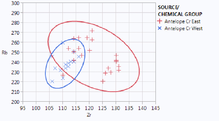
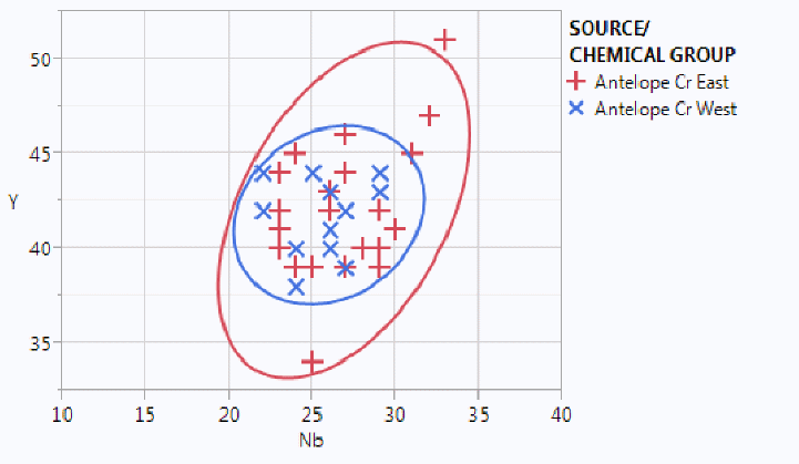
Zr versus Rb and Nb versus Y bivariate plots of source samples from Antelope Creek East and West localities. Confidence ellipses at 95%.
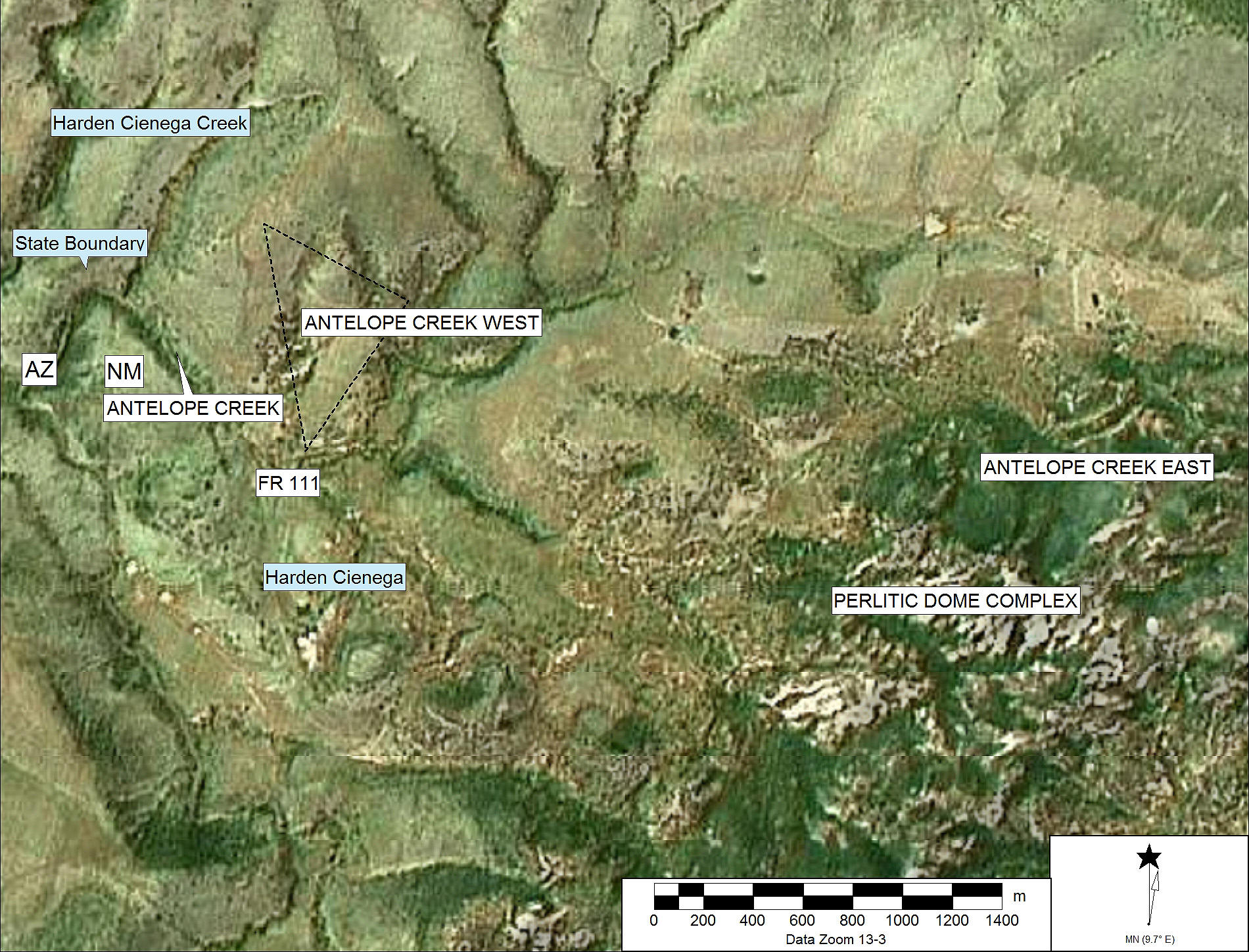
SPOT image of the Antelope Creek localities and relevant features
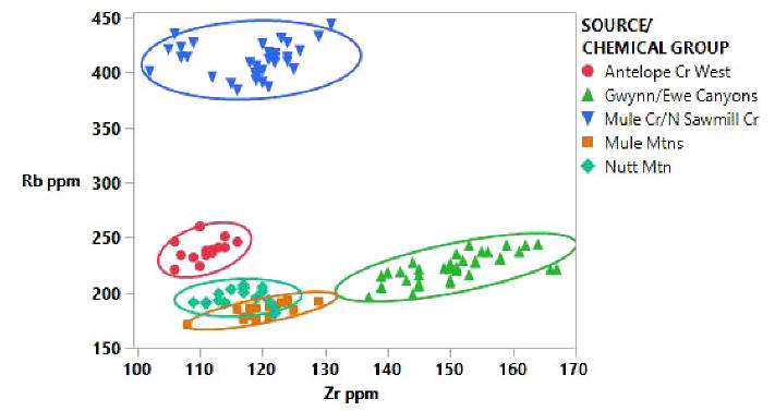
Zr/Rb bivariate plot indicating the compositional differentiation of the sub-sources in the Mogollon-Datil Volcanic Province. Confidence ellipses are at 95%.
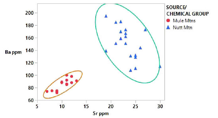
Sr/Ba bivariate plots of Mule Mountains, and Nutt Mountain source standards providing discrimination. Confidence ellipses are at 95%.
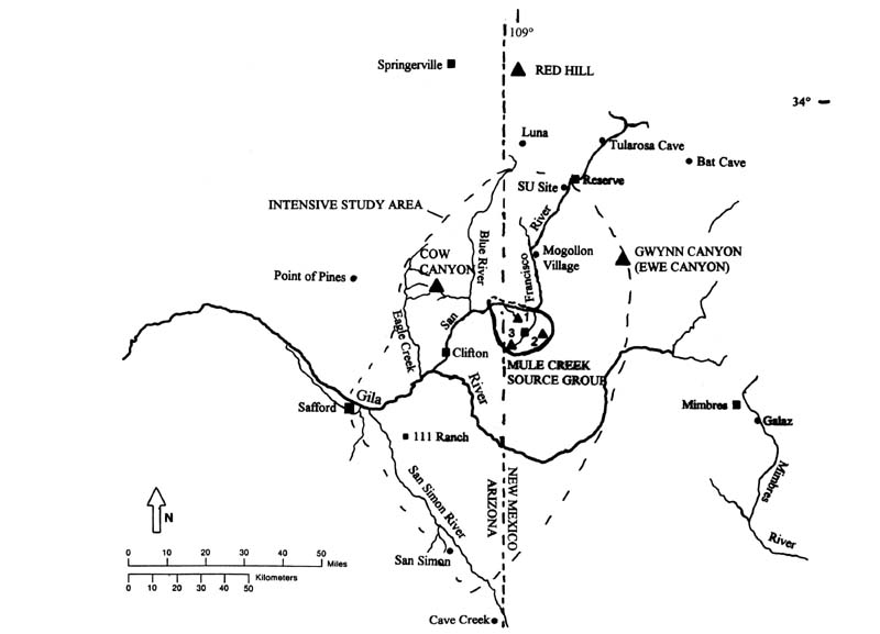
Study area with selected archaeological sites (filled circles), obsidian sources (filled triangles), modern communities (filled squares), and modern drainage system. Mule Creek Chemical Group "in-situ" localities = 1 Antelope Creek; 2 Mule Mountains; 3 Mule Creek/N. Sawmill Creek. Source localities linked to appropriate pages or data.
A recent examination of the elemental, isotopic, and geochronological (40Ar/39Ar) variability of the Mogollon-Datil volcanic province obsidian indicated the compositional similarity of these sources as mentioned above, not reflected in the isotopic and geochronology (Shackley et al. 2016).
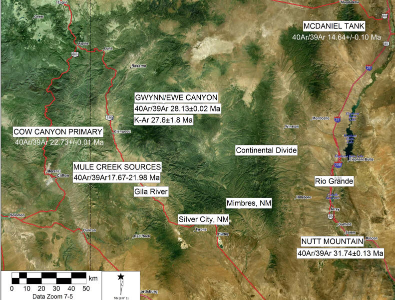
Location of Mogollon-Datil obsidian sources and 40Ar/39Ar dates (from Shackley et al. 2016).
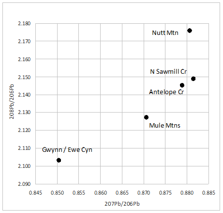
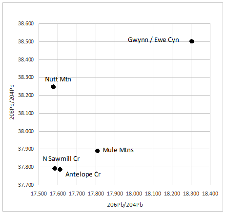
Plots of two of the Pb isotope ratios. Note the isotopic similarity between the Antelope Creek and North Sawmill Creek obsidian sources at Mule Creek, while the elemental concentrations, particularly on Rb and Nb are quite different, possibly a reflection of fractionation before eruption at North Sawmill Creek (see plots above).
THE ARCHAEOLOGY OF MULE CREEK
For a number of years now, Archaeology Southwest and the University of Arizona have been working in the Mule Creek valley attempting to unravel the rather complex history of occupation as part of a larger study of late prehistoric social networks and migration (see Mills et al. 2013). During the late 13th and early 14th century, "the occupation of the valley became more ethnically complex with migrants from the Kayenta/Tusayan region of northern Arizona coming into the valley, establishing communities alongside the Mogollon inhabitants" (see Mills et al. 2013). The obsidian sources in the valley figure prominently in understanding this complex social network that was occurring during the late 13th and 14th centuries. Archaeology Southwest has created a number of videos that discuss this unique archaeological manifestation from the perspective of principals of the project, including Deb Huntley, Rob Jones, and Katherine Dungan, scholars who have worked in the valley extensively over nearly a decade.
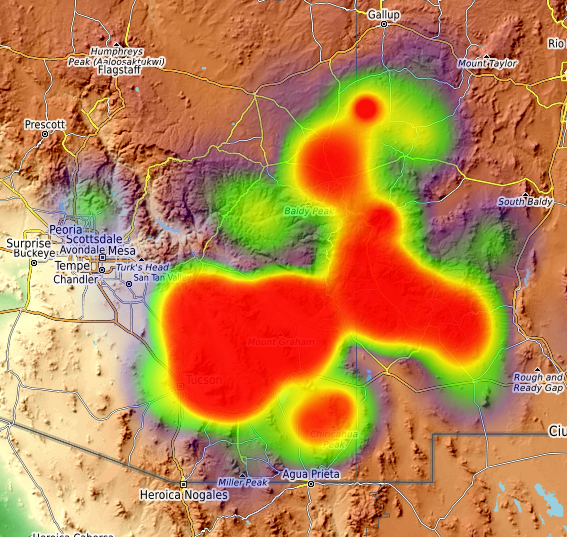
Heat map showing the distribution of Mule Creek (mainly the Antelope Cr West locality) in the North American Southwest during the Late Classic (from CyberSW, Archaeology Southwest).
REFERENCES
Brooks, W. E., and Ratté, J. C.
1985 Geologic map of Bear Mountain Quadrangle, Grant County, New Mexico. U.S.
Geological Survey Miscellaneous Field Studies Map MF-1782.
Findlow, Frank J. and Marisa Bolognese
1982a Regional Modeling of Obsidian Procurmement in the American Southwest. In Contexts for Prehistoric Exchange, edited by J.E. Ericson and T.K. Earle, pp. 53-81. Academic Press, New York.
1982b A Preliminary Analysis of Prehistoric Obsidian use Within the Mogollon Area. In Mogollon Archaeology: Proceedings of the 1980 Mogollon Conference, edited by P.H. Beckett, pp. 297-316.
LeTourneau, Philippe D.
1994 Geologic Investigations of the Antelope Wells Obsidian Source, Southern Animas Mountains, New Mexico. Paper presented at the 59th Annual Meeting of the Society for American Archaeology, Anaheim, California.
Mills, B.J., J.J. Clark, M.A. Peeples, W.R. Haas, Jr., J.M. Roberts, Jr., J.B. Hill, D.L. Huntley, L. Borck, R.L. Breiger, A. Clauset, and M.S. Shackley
2013 Transformation of Social Networks in the Late Pre-Hispanic US Southwest. PNAS 110:5785-5790.
Ratté, J. C.
1982 Geologic map of the Lower San Francisco Wilderness Study Area and
contiguous roadless area, Greenlee County, Arizona, and Catron and Grant
Counties, New Mexico. U.S. Geological Survey Miscellaneous Field Studies Map
MF-1463rA-B.
Ratte, J.C. and Brooks, W.B.
1983 Geologic map of the Mule Creek Quadrangle, Grant County, New Mexico. U.S. Geological Survey Miscellaneous Studies Map MF-1666.
1989 Geologic map of the Wilson Mountain Quadrangle, Catron and Grant Counties, New Mexico. U.S. Geological Survey Geologic Quadrangle Map GQ-1611.
Ratté, J. C., and Hedlund, D.C.
1981 Geologic map of the Hells Hole Further Planning Area (RARE II), Greenlee County, Arizona and Grant County, New Mexico. U.S. Geological Survey Miscellaneous Field Studies Map MF-1344-A.
Ratté, J. C., Marvin, R.F., and Naeser, C.W.
1984 Calderas and ash flow tuffs of the Mogollon Mountains, southwestern New Mexico. Journal of Geophysical Research 89:8713-8732.
Rhodes, R. and E. Smith
1972 Geology and Tectonic Setting of the Mule Creek Caldera, New Mexico, USA. Bulletin Volcanologíe 36:401-411.
Shackley, M.S.
1988 Sources of Archaeological Obsidian in the Southwest: An Archaeological, Petrological, and Geochemical Study. American Antiquity 53:752-772.
2005 Obsidian: Geology and Archaeology in the North American Southwest. University of Arizona Press, Tucson.
/a/ Shackley, M.S., Morgan, L., and Pyle, D. 2016. Elemental, isotopic, and geochronological variability in Mogollon-Datil volcanic province obsidian, southwestern USA: solving issues of intersource discrimination. Geoarchaeology 33:486-497.
Weber, Robert H., and Max E. Willard
1959 Reconnaissance Geologic Map of Mogollon Thirty-Minute Quadrangle. New Mexico Institute of Mining and Technology.
![]()
This page maintained by Steve Shackley (shackley@berkeley.edu).
Copyright © 2018 M. Steven Shackley. All rights reserved.
Revised: 12 June 2025
![]() Back to
the SW obsidian source page
Back to
the SW obsidian source page
![]()