SUPERIOR (PICKETPOST MOUNTAIN)
CENTRAL ARIZONA
![]()
The Picketpost Mountain source is located in Tonto National Forest (and private land), northeast Pinal County, Arizona. The Superior obsidian locality is one of the most well-known glass sources in the Southwest (Reynolds et al. 1986). The perlite here was mined historically and "Apache Tears" have been sold by individuals owning land on the source.
At Superior, the nodules are definitely marekanite remnants eroding from perlite. Reynolds et al. exhibit a photograph of marekanites embedded in the perlite matrix (1986:Figure 9). Nodules are most common on the east slope of Picketpost Mountain within a rhyolite/perlite regolith and in small washes eroding north into Queen Creek and a considerable distance west through the Queen Creek drainage. No nodules were recorded embedded within perlite in the 1980s, but marekanites were recovered with perlite still attached. Nodule densities are up to 20 per m2, but the nodule sizes are generally less than 5 cm in diameter. Some were 'on sale' that approach 8 cm. The density and nodule size recorded are probably skewed by the heavy collection that has occurred here in recent years. Cortical material is primarily a thin whitish perlite, with black glass showing through. The aphyric glass is consistently nearly transparent brown; a few nodules show some banding. The glass is an excellent knapping material, second to none in the Southwest.
Reduction of the nodules is actually uncommon at the source. This may be due to common prehistoric knowledge concerning the consistent good quality. Hankat Cave (AZ U:16:6 ASU), an Archaic period rockshelter about 20 km south exhibited a relatively large proportion of cores, flakes, debitage, and bifaces of Superior obsidian in the assemblage (Ackerly 1986). Many reduced nodules and Archaic projectile points were less than 5cm in diameter, suggesting that the nodule size found today may not be too different than during the Archaic period. The source material does appear in other Archaic through Preclassic Hohokam contexts throughout central Arizona (Shackley 2005). Indeed, in the pre-Classic contexts at Snaketown and the Grewe Site, Superior was the preferred material for what Hoffman (1997) refers to as utilitarian projectile points called Snaketown Serrated (see Shackley 2005). At AZ U:11:252 (ASM) located along Queen Creek downstream from Picketpost Mountain, the entire obsidian assemblage was from that source, and the entire production trajectory was evident from unreduced nodules, to early to late stage Snaketown Serrated preforms to finished projectile points (Shackley 2005:156-161; Wegener et al. 2002). Many of the finished projectile points are virtually identical to those produced at the Grewe Site (AZ U:2:2 ASM) not far west called by Marshall Class 1 and 2 points (Marshall 2001). Whether AZ U:11:252 was an extractive site for Grewe Site toolmakers and hunters will never be known for certain (see Wegener et al. 2002).
During the Classic in the Gila, Salt, and Tucson Basins, access to Superior was evidently restricted, probably by the Salado, and other sources such as Sauceda Mountains became more common at all sites (Shackley 2005). This doesn't seem to be the case in the Tucson Basin where Superior remained common in lithic assemblages. Reynolds et al. (1986), Wilson and Roseveare (1945); Wilson and Moore (1959) and the above are references for this source.
The two sources in central Arizona that are most frequently recovered in Arizona sites are Superior and Vulture. It is crucial to discriminate these sources, particularly in sites dating to the Sedentary (Sacaton) Period Hohokam where Superior is dominant in sites along the Middle Gila River, such as Snaketown and Grewe, while Vulture is dominant in sites along the Lower Salt River, and deviations from this pattern point to exchange likely through the market system employed through the ball games (Shackley 2005). The two sources can be discriminated using Rb, Sr, Zr, and Ba. The best discrimination is through plotting using the elements Zr and Ba (see below).
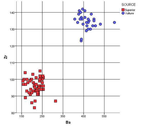
Ba versus Zr bivariate plot of Superior (Picketpost Mountain) and Vulture source standards
Raw elemental concentrations for 64 Superior (Picketpost Mtn) source standards and USGS RGM-1 obsidian standard. All measurements in parts per million (ppm).
| SAMPLE | Ti | Mn | Fe | Zn | Rb | Sr | Y | Zr | Nb | Ba |
| 1 | 765 | 496 | 7868 | 131 | 21 | 27 | 99 | 35 | 237 | |
| 2 | 709 | 456 | 7518 | 126 | 20 | 24 | 96 | 32 | 239 | |
| 3 | 808 | 498 | 7860 | 129 | 16 | 21 | 101 | 32 | 255 | |
| 4 | 756 | 493 | 7786 | 128 | 16 | 25 | 98 | 33 | 250 | |
| 5 | 831 | 473 | 7708 | 130 | 19 | 23 | 105 | 29 | 239 | |
| 6 | 778 | 478 | 7927 | 133 | 21 | 24 | 94 | 32 | 251 | |
| 7 | 796 | 500 | 7827 | 130 | 22 | 29 | 100 | 33 | 242 | |
| 8 | 899 | 537 | 8175 | 136 | 20 | 25 | 101 | 35 | 242 | |
| 9 | 718 | 479 | 7915 | 128 | 19 | 26 | 101 | 30 | 245 | |
| 10 | 829 | 479 | 7870 | 130 | 18 | 26 | 100 | 35 | 249 | |
| 11 | 796 | 504 | 8065 | 133 | 20 | 27 | 100 | 33 | 240 | |
| 12 | 1298 | 491 | 8022 | 128 | 16 | 26 | 101 | 31 | 241 | |
| 13 | 832 | 475 | 7810 | 130 | 20 | 24 | 102 | 32 | 239 | |
| 14 | 119 | 20 | 24 | 100 | 30 | 196 | ||||
| 15 | 117 | 19 | 25 | 98 | 30 | 207 | ||||
| 16 | 120 | 21 | 24 | 100 | 31 | 198 | ||||
| 17 | 115 | 19 | 24 | 97 | 30 | 158 | ||||
| 18 | 116 | 19 | 25 | 98 | 30 | 180 | ||||
| 19 | 115 | 19 | 24 | 100 | 30 | 161 | ||||
| 20 | 112 | 18 | 25 | 100 | 30 | 176 | ||||
| 21 | 107 | 20 | 24 | 99 | 29 | 191 | ||||
| 22 | 110 | 19 | 22 | 97 | 29 | 169 | ||||
| 23 | 119 | 19 | 25 | 104 | 31 | 167 | ||||
| 24 | 111 | 18 | 25 | 99 | 30 | 156 | ||||
| 25 | 968 | 362 | 7096 | 102 | 19 | 24 | 83 | 25 | 212 | |
| 26 | 914 | 348 | 7125 | 104 | 17 | 21 | 87 | 30 | 314 | |
| JB11 | 989 | 518 | 8298 | 40 | 122 | 21 | 26 | 93 | 33 | 231 |
| JB2 | 1074 | 548 | 8511 | 60 | 124 | 18 | 24 | 100 | 24 | 237 |
| JB3 | 1068 | 470 | 8459 | 48 | 118 | 22 | 27 | 94 | 33 | 221 |
| JB4 | 1043 | 479 | 8078 | 46 | 122 | 22 | 24 | 95 | 34 | 230 |
| JB5 | 1416 | 551 | 10763 | 55 | 125 | 26 | 25 | 97 | 33 | 213 |
| JB6 | 1010 | 502 | 8311 | 50 | 124 | 19 | 26 | 93 | 32 | 219 |
| JB7 | 1015 | 496 | 8241 | 52 | 123 | 23 | 27 | 94 | 33 | 255 |
| JB8 | 960 | 479 | 8154 | 45 | 123 | 19 | 23 | 96 | 35 | 249 |
| JB9 | 1017 | 455 | 8238 | 42 | 118 | 20 | 27 | 91 | 30 | 192 |
| JB10 | 989 | 433 | 7685 | 50 | 113 | 21 | 23 | 89 | 32 | 168 |
| JB11 | 937 | 424 | 7612 | 43 | 111 | 21 | 23 | 91 | 25 | 231 |
| JB12 | 1041 | 479 | 8363 | 48 | 120 | 23 | 25 | 94 | 33 | 194 |
| JB13 | 1020 | 471 | 8095 | 44 | 122 | 21 | 22 | 101 | 31 | 220 |
| JB14 | 991 | 482 | 8122 | 47 | 120 | 21 | 25 | 96 | 29 | 211 |
| JB15 | 1056 | 459 | 8072 | 49 | 115 | 20 | 27 | 96 | 29 | 233 |
| JB16 | 946 | 498 | 8072 | 40 | 125 | 23 | 24 | 95 | 30 | 234 |
| JB17 | 979 | 459 | 8087 | 43 | 123 | 20 | 26 | 92 | 31 | 230 |
| JB18 | 1351 | 485 | 9094 | 48 | 120 | 23 | 20 | 96 | 31 | 255 |
| JB19 | 1051 | 517 | 8364 | 50 | 125 | 23 | 25 | 95 | 30 | 214 |
| JB20 | 989 | 448 | 7890 | 38 | 118 | 21 | 25 | 93 | 34 | 208 |
| JB21 | 1372 | 696 | 9972 | 53 | 125 | 23 | 21 | 97 | 34 | 220 |
| JB22 | 1015 | 466 | 7948 | 45 | 115 | 22 | 24 | 94 | 30 | 247 |
| JB23 | 987 | 468 | 8216 | 45 | 118 | 23 | 28 | 94 | 28 | 225 |
| JB24 | 1003 | 521 | 8365 | 51 | 120 | 19 | 25 | 93 | 29 | 220 |
| JB25 | 963 | 428 | 7782 | 43 | 109 | 20 | 24 | 86 | 29 | 199 |
| JB26 | 1082 | 529 | 8697 | 54 | 131 | 24 | 25 | 93 | 32 | 205 |
| JB27 | 1045 | 516 | 8547 | 69 | 126 | 22 | 26 | 95 | 33 | 234 |
| JB28 | 1207 | 573 | 9427 | 50 | 127 | 23 | 26 | 94 | 30 | 225 |
| JB29 | 1036 | 476 | 8007 | 45 | 118 | 21 | 24 | 93 | 31 | 224 |
| JB30 | 899 | 398 | 7417 | 39 | 106 | 19 | 22 | 87 | 24 | 215 |
| JB31 | 1048 | 488 | 8243 | 57 | 124 | 23 | 26 | 93 | 38 | 175 |
| JB32 | 1164 | 525 | 9152 | 57 | 123 | 22 | 25 | 103 | 34 | 204 |
| JB33 | 1644 | 545 | 11132 | 57 | 123 | 24 | 27 | 102 | 33 | 253 |
| JB34 | 952 | 457 | 7822 | 46 | 119 | 19 | 23 | 92 | 33 | 199 |
| JB35 | 1026 | 530 | 8385 | 76 | 126 | 22 | 25 | 91 | 32 | 227 |
| JB36 | 994 | 466 | 8100 | 54 | 123 | 20 | 26 | 92 | 33 | 186 |
| JB37 | 1004 | 492 | 8120 | 46 | 124 | 21 | 22 | 94 | 30 | 244 |
| JB38 | 1069 | 503 | 8234 | 53 | 126 | 22 | 25 | 92 | 31 | 227 |
| RGM1-S4 | 1600 | 277 | 13366 | 36 | 146 | 106 | 28 | 220 | 9 | 805 |
1 Samples with prefix "JB" are from the Jesse Ballenger collection from the Harborlite Perlite Mine at Picketpost Mountain
Mean and central tendency for data above
|
|
N |
Minimum |
Maximum |
Mean |
Std. Deviation |
|
Ti |
53 |
709 |
1644 |
1003 |
176.7 |
|
Mn |
53 |
348 |
696 |
487 |
51.3 |
|
Fe |
53 |
7096 |
11132 |
8239 |
734.2 |
|
Zn |
38 |
37 |
75 |
49 |
7.8 |
|
Rb |
64 |
102 |
136 |
121 |
7.4 |
|
Sr |
64 |
16 |
26 |
21 |
2.0 |
|
Y |
64 |
20 |
29 |
25 |
1.7 |
|
Zr |
64 |
83 |
105 |
96 |
4.5 |
|
Nb |
64 |
24 |
38 |
31 |
2.6 |
|
Ba |
64 |
156 |
314 |
219 |
29.6 |
MAJOR AND MINOR OXIDE DATA FOR SUPERIOR AND ANALYSIS OF RGM-1 USGS SOURCE STANDARD
|
Sample |
SiO2 |
Al2O3 |
CaO |
Fe2O3 |
K2O |
MgO |
MnO |
Na2O |
TiO2 |
|
25 |
77.10 |
11.690 |
0.653 |
0.7879 |
5.947 |
0 |
0.0884 |
3.28 |
0.118 |
|
RGM1-S4 |
73.92 |
12.897 |
1.383 |
2.191 |
4.899 |
0 |
0.0375 |
4.15 |
1.262 |
References
Ackerly, N.W., 1986, Archaic Adaptive Strategies in the Middle Gila River Basin. Ph.D. dissertation, Department of Anthropology, Arizona State University, Tempe.
Hoffman, C.M., 1997, Alliance Formation and Social Interaction During the Sedentary Period: A Stylistic Analysis of Hohokam Arrowpoints. Ph.D. dissertation, Department of Anthropology, Arizona State University, Tempe.
Marshall, J.T., 2001, Flaked Stone Artifacts. In D.B. Craig (Ed.) The Grewe Archaeological Research Project, Vol. 2: Material Culture, Part II: Stone, Shell, Bone Artifacts and Biological Remains. Anthropological Papers 99-1, Northland Research, Flagstaff and Tempe, Arizona.
Reynolds, S.J., J.W. Welty, and J.E. Spencer, 1986, Volcanic History of Arizona. Arizona Bureau of Geology and Mineral Technology Fieldnotes 16:1-5.
Shackley, M.S., 2005, Obsidian: Geology and Archaeology in the North American Southwest. Tucson: University of Arizona Press.
Wegener, R.M., R. Ciolek-Torrello, and W.L. Deaver, 2002, Preliminary report of archaeological investigations along U.S. 60 at Florence Junction, Pinal County, Arizona. SRI Technical Report 02-51, Tucson.
Wilson, E.D., and R.T. Moore, 1959, Geologic map of Pinal County, Arizona. Arizona Bureau of Mines, University of Arizona, Tucson.
Wilson, E.D., and G.H. Roseveare, 1945, Arizona Perlite. Arizona Bureau of Mines Circular 12, University of Arizona, Tucson.
![]()
This page maintained by Steve Shackley (shackley@berkeley.edu).
Copyright © 2015 M. Steven Shackley. All rights reserved.
Revised: 27 December 2015
![]() Back to
the SW obsidian source page
Back to
the SW obsidian source page
![]()