VULTURE
WESTERN ARIZONA
![]()
From fieldwork October 2008:
In October 2008 with NSF funding, the Vulture area was re-visited in an attempt to locate the primary domes and better elucidate the extent and character of this source that is so prominent in Sacaton Phase Hohokam sites in the Lower Salt River Valley to the east (Shackley 2005).
This Tertiary Period source appears to be derived from earlier rhyolite eruptive events that are now part of and mostly subsumed by the andesitic Vulture and Diamond Mountains of northwestern Maricopa County, Arizona (see images below). Obsidian marekanites, similar to the 1985 study are common in the alluvium and regolith along and above Jackrabbit and Coyote Washes in the region. Located in this study were marekanites embedded in ancient ash flow tuffs, perlite, and possible lahars along Jackrabbit Wash just south of the Vulture Mountains. Most often the marekanites are found in the ashy regolith that often overlies the tuffs and perlite they have been eroding from the rhyolite domes since the Tertiary. In a few exposures, marekanites were seen in-situ in the tuffs and perlite (see image below). The first three samples analyzed in the table below were removed from the tuffs in the image below. The elemental chemistry is identical to those marekanites recovered from the alluvium in the region in 1985. So, the primary source for Vulture appears to be some Tertiary rhyolite events that have now been subsumed by later andesite volcanism. The Vulture marekanites are remnants eroding from the ash flows and perlite from what appears to have been an extensive series of eruptions "flowing" to the southeast toward what is now the Gila River. Near the "primary" source, marekanite densities are somewhat higher than that seen southeast in 1985 reaching 5-10/m2 (see below). All of the 1985 observations seem still relevant in 2008. Bipolar cores and flakes are common on ridge tops, at times reaching 10/m2. One small biface preform, possibly a Sacaton period point preform was located near Jackrabbit wash, rejected for some unknown reason.
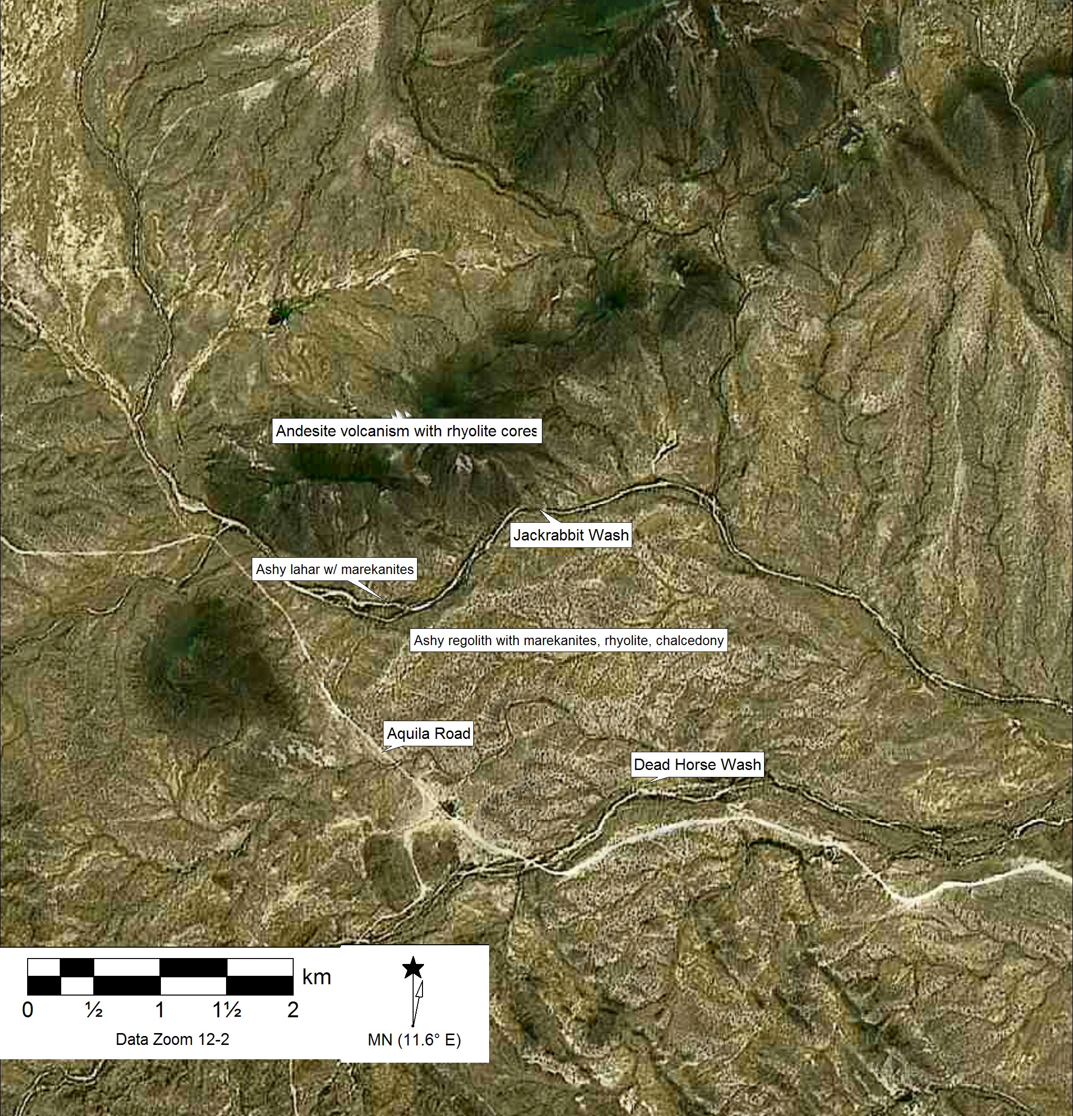
Digital elevation model of the "primary" and secondary Vulture marekanites along Jackrabbit Wash
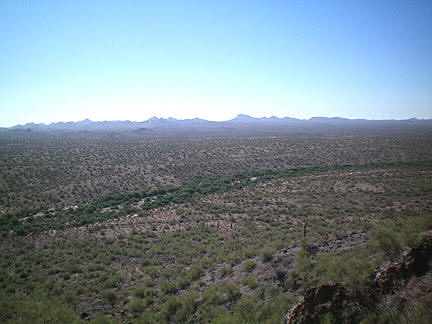
Jackrabbit Wash in center with highly eroded ash flows and perlite lava terraces in foreground and background. View to the south with the Eagletail Mountains in background. Photo taken from the slopes of andesite volcanoes in above image.
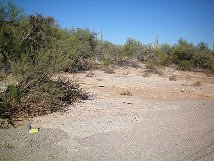
Remnant ashflow tuff along Jackrabbit Wash with marekanites.
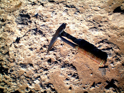
Close-up of marekanites (near hammer point and above rock hammer) in ashflow tuff above.
From Shackley (1988):
Sections 1,12 R8W, T5N; Sections 4,5,6,7,8, R7W, T5N USGS Aguila 15' Quad; and Sections 2,3,4,9,10,11,14,15,16, R7W, T5N USGS Vulture Mountains 15' Quad, northwest Maricopa County, Arizona. Previous to this study, the Vulture source was the only fully documented archaeological obsidian source in central Arizona (P. Brown 1982). The geology here is very similar to other mid-Tertiary sources in the region, especially Sauceda. A series of bedded ash-flow tuffs are punctuated with roughly circular rhyolite bodies and remnant domes that grade to perlite or vitrophyre toward the outer margins (P. Brown 1982:230). Surrounding the silicic volcanics is an alluvium that contains chunks of rhyolite and basalt as well as marekanites up to 10 cm in diameter. The nodules are found at least 20 km south and east into the Hassayampa Plain and perhaps into the Gila River system. Nodule densities near the perlite-vitrophyre are fairly low (<10 per 5m2), but the area is a known "Apache Tear" locality for local rockhounds (Simpson and Mitchell 1989).
The nodules exhibit velvet-like to water eroded thin black cortex. The aphyric glass ranges from a nearly opaque brown-green to nearly transparent. Some nodules are banded or cloudy, and one specimen was evenly banded with greenish and black bands. The nodules are an excellent medium for small biface production.
Much of this source falls within a large lithic (obsidian, rhyolite, chalcedony) procurement site AZ T:5:5(ASU) (Brown and Stone 1982). Here, as at all the marekanite sources, sporadic occurrences of bipolar reduction stations are common. The presence of cores and debitage is also sporadic, probably corresponding to the prehistoric location of nodules. Small areas, usually less than 1m2, exhibit 15 to 20 rejected flakes, angular debris, and bipolar core fragments. These bipolar reduction areas may be 5 to 50 meters apart. Brown and Stone's study indicated that only 10% of the artifacts were utilized (1982:82). The vast majority of the recovered materials were unused flakes (Brown and Stone 1982:82). This suggests that the nodules were 'test knapped' and those found suitable were removed. This pattern of bipolar test knapping and removal of desirable flakes and cores is common on all the middle to late Tertiary marekanite sources. The lack of utilized artifacts is also a common pattern. The main published work on this source is P. Brown's (1982) study, as well as Wilson et al. (1957).
The two sources in central Arizona that are most frequently recovered in Arizona sites are Superior and Vulture. It is crucial to discriminate these sources, particularly in sites dating to the Sedentary (Sacaton) Period Hohokam where Superior is dominant in sites along the Middle Gila River, such as Snaketown and Grewe, while Vulture is dominant in sites along the Lower Salt River, and deviations from this pattern point to exchange likely through the market system employed through the ball games (Shackley 2005). The two sources can be discriminated using Rb, Sr, Zr, and Ba. The best discrimination is through plotting using the elements Zr and Ba (see below).
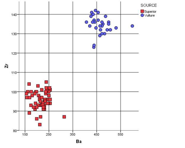
Ba versus Zr bivariate plot of Superior (Picketpost Mountain) and Vulture source standards
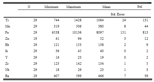
Raw elemental concentrations for Vulture source standards. All measurements in parts per million. Samples beginning with "102308 or 102408" collected in October 2008. The others collected in 1985 and data reported in Shackley (1995).
| Sample | Ti | Mn | Fe | Zn | Rb | Sr | Y | Zr | Nb | Ba |
| 102308-1-1 | 1061 | 410 | 7819 | 46 | 140 | 41 | 19 | 135 | 18 | 476 |
| 102308-1-2 | 1083 | 394 | 7707 | 52 | 131 | 37 | 21 | 134 | 22 | 472 |
| 102308-1-3 | 1161 | 356 | 7809 | 44 | 135 | 40 | 18 | 136 | 19 | 500 |
| 102308-1-4 | 1107 | 344 | 7405 | 41 | 121 | 38 | 21 | 134 | 22 | 599 |
| 102308-1-5 | 1086 | 414 | 7930 | 57 | 140 | 40 | 21 | 137 | 24 | 456 |
| 102308-1-6 | 1044 | 389 | 7464 | 54 | 138 | 40 | 21 | 134 | 20 | 464 |
| 102308-1-7 | 1375 | 506 | 10136 | 64 | 153 | 45 | 20 | 139 | 22 | 487 |
| 102308-1-8 | 1115 | 395 | 7802 | 54 | 143 | 42 | 19 | 132 | 24 | 494 |
| 102308-1-9 | 1080 | 398 | 7566 | 47 | 141 | 39 | 21 | 130 | 23 | 483 |
| 102308-1-10 | 1168 | 442 | 8142 | 94 | 136 | 39 | 20 | 141 | 21 | 456 |
| 102308-1-11 | 1037 | 391 | 7368 | 51 | 137 | 41 | 19 | 135 | 22 | 500 |
| 102308-1-12 | 1177 | 442 | 8365 | 60 | 143 | 40 | 19 | 136 | 22 | 472 |
| 102408-2-1 | 1428 | 445 | 10061 | 53 | 149 | 44 | 21 | 142 | 24 | 445 |
| 102408-2-2 | 1052 | 359 | 7103 | 45 | 129 | 41 | 19 | 133 | 19 | 447 |
| 102408-2-3 | 932 | 331 | 6538 | 48 | 124 | 38 | 16 | 129 | 20 | 463 |
| 102408-2-4 | 1063 | 414 | 7759 | 50 | 137 | 42 | 17 | 132 | 22 | 466 |
| 102408-2-5 | 1053 | 359 | 7631 | 44 | 131 | 40 | 18 | 132 | 22 | 507 |
| 102408-2-6 | 1016 | 347 | 7010 | 44 | 128 | 38 | 19 | 133 | 22 | 531 |
| 102408-2-7 | 1034 | 404 | 7924 | 49 | 135 | 40 | 18 | 130 | 19 | 472 |
| 1A | 927 | 319 | 8676 | nd1 | 147 | 42 | 19 | 139 | 24 | 426 |
| 1B | 1061 | 390 | 8925 | nd | 149 | 43 | 22 | 141 | 23 | 429 |
| 1C | 744 | 321 | 7706 | nd | 126 | 36 | 17 | 123 | 20 | 438 |
| 1D | 823 | 320 | 8000 | nd | 129 | 38 | 19 | 124 | 24 | 439 |
| 1E | 1076 | 350 | 8587 | nd | 145 | 39 | 20 | 137 | 25 | 439 |
| 2A | 1050 | 345 | 8917 | nd | 149 | 41 | 23 | 136 | 27 | 442 |
| 2B | 1071 | 366 | 8829 | nd | 151 | 42 | 18 | 140 | 25 | 435 |
| 2C | 954 | 351 | 8270 | nd | 137 | 40 | 17 | 134 | 24 | 421 |
| 2D | 1040 | 341 | 8715 | nd | 149 | 43 | 21 | 136 | 29 | 433 |
| 2E | 1038 | 366 | 8658 | nd | 141 | 42 | 20 | 136 | 29 | 407 |
1 nd=no data (not measured in earlier study)
Mean and central tendency data
for the Vulture raw data above
MAJOR OXIDE DATA FOR VULTURE AND ANALYSIS OF RGM-1 USGS SOURCE STANDARD
|
Sample |
SiO2 |
Al2O3 |
CaO |
Fe2O3 |
K2O |
MgO |
MnO |
Na2O |
TiO2 |
|
Vulture. |
|
|
|
|
|
|
|
|
|
|
102308-2-1 |
72.757 |
14.465 |
0.874 |
1.351 |
6.007 |
1.45 |
0.079 |
2.519 |
0.239 |
|
RGM1-S4 |
75.680 |
12.477 |
1.3024 |
1.806 |
4.550 |
<.001 |
0.0379 |
3.77 |
0.196 |
REFERENCES
Brown, P. (1982) Tracing prehistoric sources of obsidian. In P.E. Brown and C.L. Stone (eds.), Granite Reef: A Study in Desert Archaeology, pp. 227-241. Arizona State University Anthropological Research Papers 28, Tempe.
Brown, P.E., and C.L. Stone (1982) Data Base. In P.E. Brown and C.L. Stone (eds.), Granite Reef: A Study in Desert Archaeology, pp. 51-98. Arizona State University Anthropological Research Papers 28, Tempe.
Shackley, M.S. (1988) Sources of archaeological obsidian in the Southwest: an archaeological, petrological, and geochemical study. American Antiquity 53:752-772.
Shackley, M.S. (1995) Sources of archaeological obsidian in the Greater North American Southwest: An Update and Quantitative Analysis. American Antiquity 60:531-551.
Shackley, M.S. (2005) Obsidian: Geology and Archaeology in the North American Southwest. University of Arizona Press, Tucson.
Simpson, B.W., and J.R. Mitchell (1989) Gem Trails of Arizona. Gem Guides Book Co., Baldwin Park, California.
Wilson, E.D., R. Moore, and H.W. Pearce (1957) Geologic Map of Maricopa County, Arizona. Bureau of Mines, University of Arizona, Tucson.
![]()
This page maintained by Steve Shackley (shackley@berkeley.edu).
This research supported, in part, by the National Science Foundation (BCS-0810448)
Copyright © 2015 M. Steven Shackley. All rights reserved.
Revised: 27 December 2015
![]() Back to
the SW obsidian source page.
Back to
the SW obsidian source page.
![]()